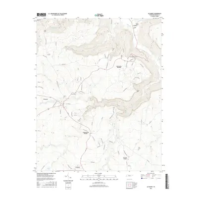
2016 Map of Altamont
USGS Topo · Published 2016About this map
Beersheba Springs stands as a central point of interest on this Grundy County landscape, where the plateau terrain meets the steep descents of Stone Door and Long Cove. The settlement pattern reflects the enduring history of the region, anchored by the town of Altamont and the industrial roots of Coalmont to the south. Numerous family and community landmarks are documented here, including Morton Cem, Fults Cem, and the Swiss Colony Cem near Gruetli-Laager. The intricate drainage system of the Cumberland Plateau is visible through the courses of the Collins River, Big Cr, and Firescald Cr. This 2016 data records a mixture of established residential streets like Dahlgren Ave and Armfield Ave alongside the natural breaks of Pepper Hollow and the headwaters of Armstrong Cr.
Find a feature on this map
84 named features on this map. Tap any name to fly to it.
Don’t see what you’re looking for? This feature index may not catch every label — zoom into the map to look around manually.
Map Details
Editions of this 2016 Altamont Map
This is the sole edition of this map. No revisions or reprints were ever made.
Other maps of this area

1893 · Mc Minnville
USGS Topo · 1:125,000

1895 · Mc Minnville
USGS Topo · 1:125,000

1895 · Sewanee
USGS Topo · 1:125,000

1936 · Palmer
USGS Topo · 1:24,000

1936 · Burrow Cove
USGS Topo · 1:24,000

1936 · Tracy City
USGS Topo · 1:24,000

1936 · Cane Hollow
USGS Topo · 1:24,000

1943 · Mc Minnville
USGS Topo · 1:100,000
1947 · Burrow Cove
USGS Topo · 1:24,000
1947 · Tracy City
USGS Topo · 1:24,000