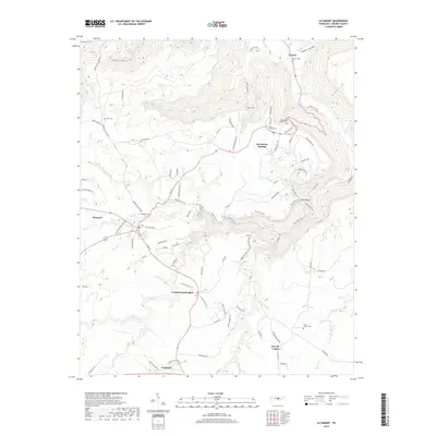
2019 Map of Altamont
USGS Topo · Published 2019About this map
Beersheba Springs and Altamont crown the plateau of Grundy County on this 2019 survey, where the rugged topography of the Cumberland Plateau meets the sharp descents of the South Cumberland State Park area. The landscape is defined by deep incisions like Savage Gulf and Big Creek Gulf, with dramatic landmarks such as the Stone Door and Ranger Falls highlighting the region's steep sandstone escarpments. The settlement pattern reveals the area's diverse cultural history, from the established communities at Gruetli-Laager and Cumberland Heights to the legacy of the Swiss Colony Cem. In the northern reaches, the Collins River winds through the valley floor near Tarlton, while a network of rural roads such as Northcutts Cove Rd and Old State Hwy 56 connect the high-country settlements. Local heritage is further preserved in numerous family and community sites, including Morton Cem, Walker Cem, and Fults Cem.
Find a feature on this map
94 named features on this map. Tap any name to fly to it.
Don’t see what you’re looking for? This feature index may not catch every label — zoom into the map to look around manually.
Map Details
Editions of this 2019 Altamont Map
This is the sole edition of this map. No revisions or reprints were ever made.
Other maps of this area

1893 · Mc Minnville
USGS Topo · 1:125,000

1895 · Mc Minnville
USGS Topo · 1:125,000

1895 · Sewanee
USGS Topo · 1:125,000

1936 · Palmer
USGS Topo · 1:24,000

1936 · Burrow Cove
USGS Topo · 1:24,000

1936 · Tracy City
USGS Topo · 1:24,000

1936 · Cane Hollow
USGS Topo · 1:24,000

1943 · Mc Minnville
USGS Topo · 1:100,000
1947 · Burrow Cove
USGS Topo · 1:24,000
1947 · Tracy City
USGS Topo · 1:24,000