2022 Map of Altamont
USGS Topo · Published 2022About this map
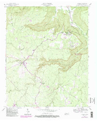
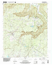
Altamont serves as a focal point for this section of the Cumberland Plateau, anchored by the Grundy County Courthouse and a network of roads branching out toward high-elevation settlements. The landscape is defined by the sharp descent of the plateau into deep coves, most notably at the Stone Door landmark where the terrain drops toward the Savage Gulf. The distribution of cemeteries across the region, from the Swiss Colony Cem near Gruetli-Laager to the Fults Cem and Walker Cem, suggests a long-established rural community pattern tied to the topography. Waterways like the Collins River and Big Cr cut through the sandstone, creating the dramatic drops seen at Falls Cr and Ranger Falls Trl. The map also captures the industrial edge of the plateau near Coalmont, where the transition from town centers to the deep forest of the gulf is most apparent.
Find a feature on this map
101 named features on this map. Tap any name to fly to it.
Don’t see what you’re looking for? This feature index may not catch every label — zoom into the map to look around manually.
Map Details
Editions of this 2022 Altamont Map
This is the sole edition of this map. No revisions or reprints were ever made.
Historical Maps of Tarlton Through Time
3 maps found