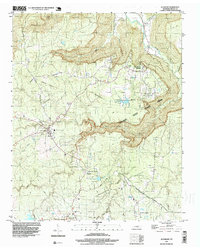
1997 Map of Altamont
USGS Topo · Published 1999About this map
Altamont and Beersheba Springs anchor this portion of the Cumberland Plateau, where the rugged topography of the Savage Gulf State Park meets the winding Collins River. The map reveals a landscape defined by dramatic elevation changes, notably the deep incisions of Savage Creek and Taylor Creek. This late-century survey captures the region's balance between conservation and industry, with established mountain communities connected by Beersheba Springs Road while Strip Mines are visible further south near Coalmont.
Find a feature on this map
39 named features on this map. Tap any name to fly to it.
Don’t see what you’re looking for? This feature index may not catch every label — zoom into the map to look around manually.
Map Details
Editions of this 1997 Altamont Map
This is the sole edition of this map. No revisions or reprints were ever made.
Other maps of this area

1893 · Mc Minnville
USGS Topo · 1:125,000

1895 · Mc Minnville
USGS Topo · 1:125,000

1895 · Sewanee
USGS Topo · 1:125,000

1936 · Palmer
USGS Topo · 1:24,000

1936 · Burrow Cove
USGS Topo · 1:24,000

1936 · Tracy City
USGS Topo · 1:24,000

1936 · Cane Hollow
USGS Topo · 1:24,000

1943 · Mc Minnville
USGS Topo · 1:100,000
1947 · Burrow Cove
USGS Topo · 1:24,000
1947 · Tracy City
USGS Topo · 1:24,000