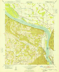
1948 Map of Altenburg
USGS Topo · Published 1948About this map
The Mississippi River dominates this mid-century landscape, carving a wide path between Perry County, Missouri, and Jackson County, Illinois. On the Missouri side, the German-heritage settlements of Altenburg, Frohna, and Wittenberg anchor the rolling uplands of Brazeau township. The riverfront is characterized by working commerce and transit, evidenced by numerous river landings such as Star Landing, Leimbach Landing, and Brunkhorst Landing.
Find a feature on this map
42 named features on this map. Tap any name to fly to it.
Don’t see what you’re looking for? This feature index may not catch every label — zoom into the map to look around manually.
Map Details
Editions of this 1948 Altenburg Map
2 editions found
Other maps of this area

1910 · Murphysboro
USGS Topo · 1:62,500

1916 · Campbell Hill
USGS Topo · 1:62,500

1918 · Altenburg
USGS Topo · 1:62,500

1918 · Campbell Hill
USGS Topo · 1:62,500

1924 · Alto Pass
USGS Topo · 1:62,500

1925 · Altenburg
USGS Topo · 1:62,500

1938 · Murphysboro
USGS Topo · 1:62,500

1947 · Alto Pass
USGS Topo · 1:62,500

1947 · Crosstown
USGS Topo · 1:24,000

1947 · Oak Ridge
USGS Topo · 1:24,000