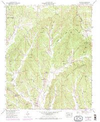
1950 Map of Altitude
USGS Topo · Published 1971About this map
Altitude serves as a central point in this topographic study of Prentiss County, Mississippi, which reveals a landscape defined by the Tennessee Valley Divide and the serpentine Heading Mill Hollow. The settlement patterns here are deeply rooted in the local topography, with family and community landmarks such as Mt Pleasant Church and Hills Chapel School situated near the headwaters of the regional creek system.
Find a feature on this map
73 named features on this map. Tap any name to fly to it.
Don’t see what you’re looking for? This feature index may not catch every label — zoom into the map to look around manually.
Map Details
Editions of this 1950 Altitude Map
3 editions found
Other maps of this area

1921 · Booneville
USGS Topo · 1:48,000

1922 · Booneville
USGS Topo · 1:62,500

1935 · Holcut
USGS Topo · 1:24,000

1935 · Leedy
USGS Topo · 1:24,000

1935 · Glens
USGS Topo · 1:24,000

1950 · Corinth
USGS Topo · 1:62,500

1950 · Paden
USGS Topo · 1:24,000
1950 · Burnsville
USGS Topo · 1:24,000

1950 · Glens
USGS Topo · 1:24,000

1950 · Altitude
USGS Topo · 1:24,000