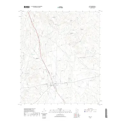
2019 Map of Alto
USGS Topo · Published 2019About this map
Alto serves as the primary hub of this East Texas landscape, where a dense network of county roads radiates from the town center towards the surrounding piney hills. The terrain is defined by prominent elevations such as Bradford Mtn, Carter Mtn, and Bald Mtn, which rise above the creek valleys of Big Atoy Cr and Little Atoy Cr. To the northwest lies the community of Redlawn, while the map is punctuated by numerous family and community landmarks vital for genealogical research, including Bradford Cem, Green Cem, and Shiloh Cem. The presence of several smaller watercourses like Turkey Cr and Bowles Cr, along with the secluded Bowles Spring, illustrates a well-watered agricultural and timber region. This survey captures the rural character and established settlement patterns of Cherokee County in the late 2010s.
Find a feature on this map
86 named features on this map. Tap any name to fly to it.
Don’t see what you’re looking for? This feature index may not catch every label — zoom into the map to look around manually.
Map Details
Editions of this 2019 Alto Map
This is the sole edition of this map. No revisions or reprints were ever made.
Other maps of this area

1943 · Cushing
USGS Topo · 1:62,500

1943 · Rusk
USGS Topo · 1:62,500

1945 · Cushing
USGS Topo · 1:62,500

1945 · Rusk
USGS Topo · 1:62,500

1946 · Alto
USGS Topo · 1:62,500

1952 · Douglass
USGS Topo · 1:62,500

1953 · Palestine
USGS Topo · 1:250,000

1957 · Palestine
USGS Topo · 1:250,000
1973 · Atoy
USGS Topo · 1:24,000
1973 · Pryor Mountain
USGS Topo · 1:24,000