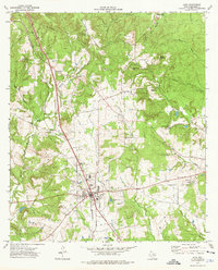
1973 Map of Alto
USGS Topo · Published 1976About this map
Alto serves as the primary hub of this East Texas landscape, situated at the junction of several regional routes and the St. Louis Southwestern railroad. The 1970s terrain is defined by a series of prominent elevations, including Bradford Mountain, Carter Mountain, and Bald Mountain, which rise above a network of drainages such as Larrison Creek and Beaver Creek. This survey captures the rural community structure of Cherokee County, where small centers like Redlawn and Central High are anchored by local schools and country churches.
Find a feature on this map
41 named features on this map. Tap any name to fly to it.
Don’t see what you’re looking for? This feature index may not catch every label — zoom into the map to look around manually.
Map Details
Editions of this 1973 Alto Map
This is the sole edition of this map. No revisions or reprints were ever made.
Other maps of this area

1943 · Cushing
USGS Topo · 1:62,500

1943 · Rusk
USGS Topo · 1:62,500

1945 · Cushing
USGS Topo · 1:62,500

1945 · Rusk
USGS Topo · 1:62,500

1946 · Alto
USGS Topo · 1:62,500

1952 · Douglass
USGS Topo · 1:62,500

1953 · Palestine
USGS Topo · 1:250,000

1957 · Palestine
USGS Topo · 1:250,000
1973 · Atoy
USGS Topo · 1:24,000
1973 · Pryor Mountain
USGS Topo · 1:24,000