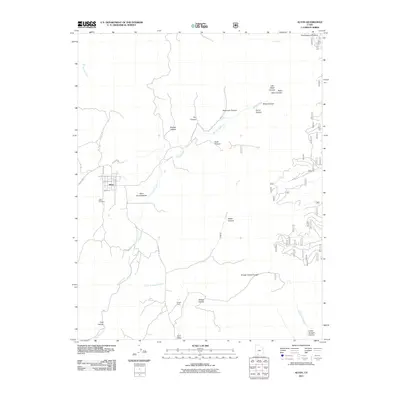
2011 Map of Alton
USGS Topo · Published 2011About this map
Alton stands as the primary settlement in this high-altitude landscape of southern Utah, its grid-like street pattern including W Center St and W 200 North St positioned near the Alton Cemetery. The terrain is defined by a complex drainage system where Kanab Creek flows past the Alton Amphitheater, fed by various canyons such as Roundy Canyon and Rush Canyon. To the east, the Paunsaugunt Plateau rises sharply, while the southern reaches of the map transition into the lower elevations of Sink Valley and the Swapp Hollow drainage area.
Find a feature on this map
31 named features on this map. Tap any name to fly to it.
Don’t see what you’re looking for? This feature index may not catch every label — zoom into the map to look around manually.
Map Details
Editions of this 2011 Alton Map
This is the sole edition of this map. No revisions or reprints were ever made.
Other maps of this area

1886 · Kanab
USGS Topo · 1:250,000

1953 · Cedar City
USGS Topo · 1:250,000

1958 · Cedar City
USGS Topo · 1:250,000

1958 · Orderville
USGS Topo · 1:62,500

1958 · Panguitch Lake
USGS Topo · 1:62,500

1962 · Cedar City
USGS Topo · 1:250,000

1966 · Alton
USGS Topo · 1:24,000

1966 · Bald Knoll
USGS Topo · 1:24,000

1966 · George Mtn
USGS Topo · 1:24,000
1966 · Podunk Creek
USGS Topo · 1:24,000