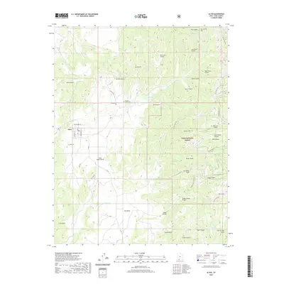
2020 Map of Alton
USGS Topo · Published 2020About this map
Alton occupies a high valley in Kane County, situated at the base of the dramatic Paunsaugunt Plateau. This survey details a landscape defined by sharp geological transitions, from the high elevation of the Pink Cliffs and Sunset Cliffs down to the drainage of Kanab Cr. Local genealogy is well-represented by the Alton Cem, the Roundy Cem, and the Roundy / Johnson Cem, indicating the deep roots of the Roundy and Johnson families in this ranching and coal-rich region. The presence of Coal Mine Rd and Coal Hollow south of the town center points to the area's long-standing connection to resource extraction. Much of the eastern portion of the map is protected within the Dixie National Forest, where a network of recreation paths like the Grand View Trail and Paunsaugunt Atv Trail traverse the ridgelines.
Find a feature on this map
50 named features on this map. Tap any name to fly to it.
Don’t see what you’re looking for? This feature index may not catch every label — zoom into the map to look around manually.
Map Details
Editions of this 2020 Alton Map
This is the sole edition of this map. No revisions or reprints were ever made.
Other maps of this area

1886 · Kanab
USGS Topo · 1:250,000

1953 · Cedar City
USGS Topo · 1:250,000

1958 · Cedar City
USGS Topo · 1:250,000

1958 · Orderville
USGS Topo · 1:62,500

1958 · Panguitch Lake
USGS Topo · 1:62,500

1962 · Cedar City
USGS Topo · 1:250,000

1966 · Alton
USGS Topo · 1:24,000

1966 · Bald Knoll
USGS Topo · 1:24,000

1966 · George Mtn
USGS Topo · 1:24,000
1966 · Podunk Creek
USGS Topo · 1:24,000