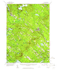
1957 Map of Alton
USGS Topo · Published 1961About this map
Alton Bay and the village of Alton anchor the northern reaches of this New Hampshire landscape, where the Merrymeeting River flows through a series of valleys flanked by significant ridgelines. The interior is characterized by a high density of named corners and crossroads, such as Stockbridge Corners and Meaderboro Corner, reflecting a mature rural settlement pattern before post-war suburbanization significantly altered the landscape. Educational and religious institutions, including the Austin Cate Academy and Memorial Chapel, are well-established focal points for the surrounding townships.
Find a feature on this map
106 named features on this map. Tap any name to fly to it.
Don’t see what you’re looking for? This feature index may not catch every label — zoom into the map to look around manually.
Map Details
Editions of this 1957 Alton Map
4 editions found

Other maps of this area

1891 · Berwick
USGS Topo · 1:62,500

1891 · Newfield
USGS Topo · 1:62,500

1893 · Dover
USGS Topo · 1:62,500

1893 · Berwick
USGS Topo · 1:62,500

1893 · Newfield
USGS Topo · 1:62,500

1909 · Winnepesaukee
USGS Topo · 1:62,500

1916 · Dover
USGS Topo · 1:62,500

1917 · Mt. Pawtuckaway
USGS Topo · 1:62,500

1918 · Dover
USGS Topo · 1:62,500

1919 · Mt. Pawtuckaway
USGS Topo · 1:62,500