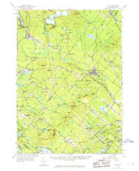
1957 Map of Alton
USGS Topo · Published 1969About this map
Lake Winnipesaukee (Alton Bay) marks the northwestern corner of this landscape, where the Boston and Maine railroad reaches the waters edge at Alton Bay. The interior is defined by the high ground of Birch Ridge and the Blue Hill Range, sheltering numerous smaller water bodies such as Merrymeeting Lake and Bow Lake. A network of 19th-century crossroads and small settlements like New Durham Corner, South Barnstead, and Stockbridge Corners anchors the rural economy, while institutional landmarks like the Austin Cate Academy and Powder Mill Fish Hatchery provide local character. In Farmington, the concentration of schools and the Boston and Maine line suggests a hub of activity contrasting with the scattered corners and hilltop lookouts like the Lookout Tower on Blue Job Mtn.
Find a feature on this map
127 named features on this map. Tap any name to fly to it.
Don’t see what you’re looking for? This feature index may not catch every label — zoom into the map to look around manually.
Map Details
Editions of this 1957 Alton Map
4 editions found

Other maps of this area

1891 · Berwick
USGS Topo · 1:62,500

1891 · Newfield
USGS Topo · 1:62,500

1893 · Dover
USGS Topo · 1:62,500

1893 · Berwick
USGS Topo · 1:62,500

1893 · Newfield
USGS Topo · 1:62,500

1909 · Winnepesaukee
USGS Topo · 1:62,500

1916 · Dover
USGS Topo · 1:62,500

1917 · Mt. Pawtuckaway
USGS Topo · 1:62,500

1918 · Dover
USGS Topo · 1:62,500

1919 · Mt. Pawtuckaway
USGS Topo · 1:62,500