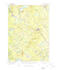
1957 Map of Alton
USGS Topo · Published 1977About this map
Lake Winnipesaukee anchors the northwest corner of this New Hampshire landscape, where the town of Alton Bay serves as a gateway to the water. The terrain is defined by the Blue Hill Range and a series of high ridges, including Birch Ridge and New Durham Ridge, which separate the drainage of the Merrymeeting River from the Cocheco River. This mid-century survey captures a network of rural hamlets and crossroads such as Center Strafford and North Barnstead, many linked by the Boston and Maine RR. Educational and community anchors like the Austin Cate Academy and Memorial Sch are clearly marked alongside the Powder Mill Fish Hatchery near Merrymeeting Lake. The map reveals a transition from the lakeside recreation of Alton to the upland farming and forestry of the interior hills.
Find a feature on this map
113 named features on this map. Tap any name to fly to it.
Don’t see what you’re looking for? This feature index may not catch every label — zoom into the map to look around manually.
Map Details
Editions of this 1957 Alton Map
4 editions found

Other maps of this area

1891 · Berwick
USGS Topo · 1:62,500

1891 · Newfield
USGS Topo · 1:62,500

1893 · Dover
USGS Topo · 1:62,500

1893 · Berwick
USGS Topo · 1:62,500

1893 · Newfield
USGS Topo · 1:62,500

1909 · Winnepesaukee
USGS Topo · 1:62,500

1916 · Dover
USGS Topo · 1:62,500

1917 · Mt. Pawtuckaway
USGS Topo · 1:62,500

1918 · Dover
USGS Topo · 1:62,500

1919 · Mt. Pawtuckaway
USGS Topo · 1:62,500