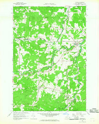
1966 Map of Altona
USGS Topo · Published 1968About this map
The northern boundary of Canada United States defines the upper edge of this mid-1960s study, where the international line cuts through the drainages of the English River and its various tributaries. This borderland landscape in Clinton County is marked by several small hamlets, including Mooers Forks and Altona, which serve as local hubs for the surrounding timber and agricultural lands. The map details a transition in transportation, showing both active rail lines and the Old Railroad Grade running west from Irona.
Find a feature on this map
59 named features on this map. Tap any name to fly to it.
Don’t see what you’re looking for? This feature index may not catch every label — zoom into the map to look around manually.
Map Details
Editions of this 1966 Altona Map
2 editions found
Other maps of this area

1895 · Mooers
USGS Topo · 1:62,500

1899 · Mooers
USGS Topo · 1:62,500

1915 · Churubusco
USGS Topo · 1:62,500

1942 · Mooers
USGS Topo · 1:62,500

1943 · Churubusco
USGS Topo · 1:62,500

1943 · Mooers
USGS Topo · 1:62,500

1950 · Lake Champlain
USGS Topo · 1:250,000
1956 · Mooers
USGS Topo · 1:62,500

1958 · Lake Champlain
USGS Topo · 1:250,000

1962 · Lake Champlain
USGS Topo · 1:250,000