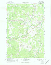
1966 Map of Altona
USGS Topo · Published 1984About this map
The Canada-United States international boundary defines the northern edge of this mid-1960s survey, where U S Customs stands at the border crossing north of Cannon Corners. The landscape transitions from the southern edge of the State Forest Preserve down into the river valleys of the English River and the Great Chazy River. In the town of Altona, the local infrastructure is anchored by the Altona Central Sch and Holy Angels church, situated near the shores of Miner Lake.
Find a feature on this map
61 named features on this map. Tap any name to fly to it.
Don’t see what you’re looking for? This feature index may not catch every label — zoom into the map to look around manually.
Map Details
Editions of this 1966 Altona Map
2 editions found
Other maps of this area

1895 · Mooers
USGS Topo · 1:62,500

1899 · Mooers
USGS Topo · 1:62,500

1915 · Churubusco
USGS Topo · 1:62,500

1942 · Mooers
USGS Topo · 1:62,500

1943 · Churubusco
USGS Topo · 1:62,500

1943 · Mooers
USGS Topo · 1:62,500

1950 · Lake Champlain
USGS Topo · 1:250,000
1956 · Mooers
USGS Topo · 1:62,500

1958 · Lake Champlain
USGS Topo · 1:250,000

1962 · Lake Champlain
USGS Topo · 1:250,000