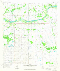
1958 Map of Alva
USGS Topo · Published 1967About this map
The Caloosahatchee River serves as the primary artery through this Florida landscape, connecting the established settlement of Alva with Denaud further upstream. During the late 1950s, the southern portion of the map reveals the nascent grid of Lehigh Acres, a massive residential development emerging from former ranch lands. This transformation is marked by a rigorous network of drainage channels, including the Love Canal, King Canal, and West Baker Canal, which were engineered to facilitate inland settlement.
Find a feature on this map
29 named features on this map. Tap any name to fly to it.
Don’t see what you’re looking for? This feature index may not catch every label — zoom into the map to look around manually.
Map Details
Editions of this 1958 Alva Map
4 editions found
Other maps of this area

1956 · Telegraph Swamp
USGS Topo · 1:24,000

1956 · West Palm Beach
USGS Topo · 1:250,000

1957 · West Palm Beach
USGS Topo · 1:250,000

1957 · Telegraph Swamp SE
USGS Topo · 1:24,000

1958 · West Palm Beach
USGS Topo · 1:250,000

1958 · Felda
USGS Topo · 1:24,000

1958 · Olga
USGS Topo · 1:24,000

1958 · Alva SW
USGS Topo · 1:24,000

1958 · Alva
USGS Topo · 1:24,000

1958 · Sears
USGS Topo · 1:24,000