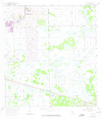
1958 Map of Alva SE
USGS Topo · Published 1971About this map
Lehigh Acres appears in a moment of rapid residential expansion at the western edge of this survey, with extensive street grids and a Golf Course newly laid out by the early 1970s. The landscape transition is stark, moving from these planned suburban blocks into the untamed wetlands of the Florida interior. The drainage patterns across the terrain are defined by natural features like Twelvemile Slough and Fussel Slough, alongside man-made interventions such as the Townsend Canal. In the lower reaches of the quadrangle, the Corkscrew Lookout Tower stands as a lonely sentinel over the flat pinelands and marshy basins. This map captures the intersection of three counties—Lee, Hendry, and Collier—revealing how infrastructure like Route 82 began to pierce through the natural drainage systems of Curison Gully.
Find a feature on this map
10 named features on this map. Tap any name to fly to it.
Don’t see what you’re looking for? This feature index may not catch every label — zoom into the map to look around manually.
Map Details
Editions of this 1958 Alva SE Map
3 editions found

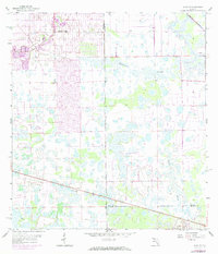
Other maps of this area

1956 · West Palm Beach
USGS Topo · 1:250,000

1957 · West Palm Beach
USGS Topo · 1:250,000

1958 · West Palm Beach
USGS Topo · 1:250,000

1958 · Corkscrew NW
USGS Topo · 1:24,000

1958 · Immokalee
USGS Topo · 1:24,000

1958 · Felda
USGS Topo · 1:24,000

1958 · Olga
USGS Topo · 1:24,000

1958 · Alva SW
USGS Topo · 1:24,000

1958 · Alva
USGS Topo · 1:24,000

1958 · Sears
USGS Topo · 1:24,000