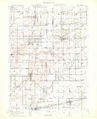
1913 Map of Alvordton
USGS Topo · Published 1913About this map
The Michigan-Ohio boundary line cuts across this 1913 landscape, defining a region where rural agriculture and a dense network of early 20th-century railroads intersect. Major junctions such as Alvordton and West Unity serve as hubs for the Wabash RR and the Cincinnati Northern RR, showing how critical rail transport was for the local economy before the dominance of automobiles. The map detail highlights the high density of rural education and faith, with dozens of numbered schoolhouses and spiritual landmarks like the Mennonite Church near Archbold and Gray Church further north.
Find a feature on this map
91 named features on this map. Tap any name to fly to it.
Don’t see what you’re looking for? This feature index may not catch every label — zoom into the map to look around manually.
Map Details
Editions of this 1913 Alvordton Map
3 editions found
Other maps of this area

1907 · Defiance
USGS Topo · 1:62,500

1908 · Napoleon
USGS Topo · 1:62,500

1909 · Defiance
USGS Topo · 1:62,500

1911 · Wauseon
USGS Topo · 1:62,500

1913 · Wauseon
USGS Topo · 1:62,500

1913 · Alvordton
USGS Topo · 1:62,500

1914 · Pioneer
USGS Topo · 1:62,500

1914 · Bryan
USGS Topo · 1:62,500

1943 · Bryan
USGS Topo · 1:62,500

1943 · Wauseon
USGS Topo · 1:62,500