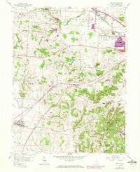
1958 Map of Amanda
USGS Topo · Published 1972About this map
Rock Mill and the headwaters of the Hocking River anchor the northern landscape of this Fairfield County region during the mid-20th century. The area is defined by a transition from the agricultural plains of Bloom and Amanda townships into the increasingly broken topography of Hocking and Madison. A dense network of family and community burial grounds, such as Crumley Cem and Wesley Chapel Cem, provides a detailed record of rural settlement patterns. Transport is dominated by the Chesapeake and Ohio and Penn Central rail lines, which connect the smaller communities of Delmont and Hooker to the expanding city of Lancaster. To the south, the terrain becomes more distinct with features like Jacobs Ladder and Christmas Rocks rising above the drainage of Arney Run, while the State Industrial Sch occupies a significant tract on the eastern edge.
Find a feature on this map
53 named features on this map. Tap any name to fly to it.
Don’t see what you’re looking for? This feature index may not catch every label — zoom into the map to look around manually.
Map Details
Editions of this 1958 Amanda Map
Other maps of this area

1907 · Lancaster
USGS Topo · 1:62,500

1907 · Thurston
USGS Topo · 1:62,500

1909 · Lancaster
USGS Topo · 1:62,500

1909 · Thurston
USGS Topo · 1:62,500

1914 · Circleville
USGS Topo · 1:62,500

1925 · East Columbus
USGS Topo · 1:62,500

1943 · Circleville
USGS Topo · 1:62,500

1943 · East Columbus
USGS Topo · 1:62,500

1947 · Columbus
USGS Topo · 1:250,000
1955 · Canal Winchester
USGS Topo · 1:24,000