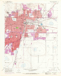
1956 Map of Amarillo East
USGS Topo · Published 1968About this map
Amarillo is depicted at a moment of significant mid-century expansion, with the 1967 purple-tinted revisions showing substantial urban growth into the surrounding plains. The city's northern landscape is anchored by recreation and social institutions like the Ross Rogers Golf Course and Thompson Park, while the central areas reveal a dense network of schools such as Palo Duro High Sch and Robert E Lee Sch. A massive convergence of rail infrastructure dominates the eastern geography, where the Atchison Topeka and Santa Fe and Chicago Rock Island and Pacific lines cross near the Stockyards. To the south, aviation and industry define the skyline with Tradewind Airport and the Palo Duro Airport situated near a Refinery and Oil Tanks. This map captures the shift from a traditional rail hub to a modern automotive city, evidenced by the developing highway corridors passing near the National Guard Armory and Amarillo College.
Find a feature on this map
83 named features on this map. Tap any name to fly to it.
Don’t see what you’re looking for? This feature index may not catch every label — zoom into the map to look around manually.
Map Details
Editions of this 1956 Amarillo East Map
3 editions found
Other maps of this area

1934 · Cliffside
USGS Topo · 1:62,500

1936 · Cliffside
USGS Topo · 1:62,500

1953 · Pleasant Valley
USGS Topo · 1:24,000

1953 · Mayer
USGS Topo · 1:24,000

1953 · Cliffside
USGS Topo · 1:24,000

1954 · Amarillo
USGS Topo · 1:250,000

1956 · Amarillo East
USGS Topo · 1:24,000

1956 · Thomas Ranch
USGS Topo · 1:24,000

1956 · Pullman
USGS Topo · 1:24,000

1958 · Amarillo
USGS Topo · 1:250,000