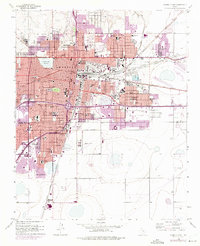
1956 Map of Amarillo East
USGS Topo · Published 1975About this map
The city of Amarillo serves as a critical junction for the High Plains rail economy, where the Chicago Rock Island and Pacific, the Atchison Topeka and Santa Fe, and the Fort Worth and Denver railroads converge. This mid-century survey captures a period of significant urban expansion, with purple-tinted updates illustrating the residential growth pushing south toward Zita and the Potter Co Randall Co line. The urban landscape is dense with educational and religious institutions, ranging from St Marys Academy to the sprawling grounds of Amarillo College.
Find a feature on this map
77 named features on this map. Tap any name to fly to it.
Don’t see what you’re looking for? This feature index may not catch every label — zoom into the map to look around manually.
Map Details
Editions of this 1956 Amarillo East Map
3 editions found
Other maps of this area

1934 · Cliffside
USGS Topo · 1:62,500

1936 · Cliffside
USGS Topo · 1:62,500

1953 · Pleasant Valley
USGS Topo · 1:24,000

1953 · Mayer
USGS Topo · 1:24,000

1953 · Cliffside
USGS Topo · 1:24,000

1954 · Amarillo
USGS Topo · 1:250,000

1956 · Amarillo East
USGS Topo · 1:24,000

1956 · Thomas Ranch
USGS Topo · 1:24,000

1956 · Pullman
USGS Topo · 1:24,000

1958 · Amarillo
USGS Topo · 1:250,000