1955 Map of Ambler River A-5
USGS Topo · Published 1972About this map
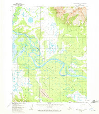
The Kobuk River meanders through this wilderness landscape as it appeared in the mid-1950s, revealing a complex network of sloughs and tributary streams. Among the most significant archaeological and historical landmarks is Onion Portage, a critical site for understanding early human migration and caribou hunting patterns. To the north, the Jade Mountains rise sharply, while the southern reaches of the map are defined by the Waring Mountains and the distinct geomorphology of the Little Kobuk Sand Dunes. Numerous seasonal or hunting structures are indicated by Cabin markers along the waterways, such as Jade Creek and Akillik River. This survey captures the remote character of the Northwest Arctic region, showing the land as it was mapped by the Department of the Interior Geological Survey using 1955 aerial photography.
Find a feature on this map
14 named features on this map. Tap any name to fly to it.
Don’t see what you’re looking for? This feature index may not catch every label — zoom into the map to look around manually.
Map Details
Editions of this 1955 Ambler River A-5 Map
3 editions found
Historical Maps of Northwest Arctic Through Time
847 maps found

1950 Bendeleben C-1
Northwest Arctic Borough, AK

1950 Bendeleben C-2
Northwest Arctic Borough, AK

1950 Bendeleben C-3
Northwest Arctic Borough, AK

1950 Bendeleben C-4
Northwest Arctic Borough, AK

1950 Bendeleben D-1
Northwest Arctic Borough, AK

1950 Bendeleben D-2
Northwest Arctic Borough, AK

1950 Bendeleben D-3
Northwest Arctic Borough, AK

1950 Bendeleben D-4
Northwest Arctic Borough, AK

1950 Candle C-5
Northwest Arctic Borough, AK

1950 Candle C-6
Northwest Arctic Borough, AK

1950 Kotzebue A-1
Northwest Arctic Borough, AK

1950 Kotzebue A-2
Northwest Arctic Borough, AK

1950 Kotzebue A-3
Northwest Arctic Borough, AK

1950 Kotzebue A-4
Northwest Arctic Borough, AK

1950 Kotzebue A-5
Northwest Arctic Borough, AK

1950 Kotzebue B-4
Northwest Arctic Borough, AK

1950 Kotzebue B-5
Northwest Arctic Borough, AK

1950 Kotzebue C-4
Northwest Arctic Borough, AK

1950 Kotzebue C-5
Northwest Arctic Borough, AK

1951 Ambler River
Northwest Arctic Borough, AK

1951 Baird Mountains
Northwest Arctic Borough, AK

1951 Candle D-5
Northwest Arctic Borough, AK

1951 Candle D-6
Northwest Arctic Borough, AK

1951 Candle
Northwest Arctic Borough, AK

1951 Kotzebue C-1
Northwest Arctic Borough, AK

1951 Kotzebue D-1
Northwest Arctic Borough, AK

1951 Kotzebue D-2
Northwest Arctic Borough, AK

1951 Selawik A-5
Northwest Arctic Borough, AK

1951 Selawik A-6
Northwest Arctic Borough, AK

1951 Selawik B-5
Northwest Arctic Borough, AK

1951 Selawik B-6
Northwest Arctic Borough, AK

1951 Selawik C-6
Northwest Arctic Borough, AK

1951 Selawik D-6
Northwest Arctic Borough, AK

1952 Noatak A-3
Northwest Arctic Borough, AK

1952 Noatak A-4
Northwest Arctic Borough, AK

1952 Noatak C-5
Northwest Arctic Borough, AK

1952 Noatak D-7
Northwest Arctic Borough, AK

1952 Selawik D-6
Northwest Arctic Borough, AK

1954 Candle C-2
Northwest Arctic Borough, AK

1954 Candle D-2
Northwest Arctic Borough, AK

1955 Ambler River A-4
Northwest Arctic Borough, AK

1955 Ambler River A-5
Northwest Arctic Borough, AK

1955 Ambler River A-6
Northwest Arctic Borough, AK

1955 Baird Mountains A-1
Northwest Arctic Borough, AK

1955 Baird Mountains A-2
Northwest Arctic Borough, AK

1955 Baird Mountains A-3
Northwest Arctic Borough, AK

1955 Baird Mountains A-4
Northwest Arctic Borough, AK

1955 Baird Mountains A-5
Northwest Arctic Borough, AK

1955 Baird Mountains A-6
Northwest Arctic Borough, AK

1955 Baird Mountains B-3
Northwest Arctic Borough, AK

1955 Baird Mountains B-4
Northwest Arctic Borough, AK

1955 Baird Mountains B-5
Northwest Arctic Borough, AK

1955 Baird Mountains B-6
Northwest Arctic Borough, AK

1955 Baird Mountains C-3
Northwest Arctic Borough, AK

1955 Baird Mountains C-4
Northwest Arctic Borough, AK

1955 Baird Mountains C-5
Northwest Arctic Borough, AK

1955 Baird Mountains C-6
Northwest Arctic Borough, AK

1955 Baird Mountains D-3
Northwest Arctic Borough, AK

1955 Baird Mountains D-4
Northwest Arctic Borough, AK

1955 Baird Mountains D-5
Northwest Arctic Borough, AK

1955 Baird Mountains D-6
Northwest Arctic Borough, AK

1955 Candle C-3
Northwest Arctic Borough, AK

1955 Candle C-4
Northwest Arctic Borough, AK

1955 Candle D-3
Northwest Arctic Borough, AK

1955 Candle D-4
Northwest Arctic Borough, AK

1955 Candle
Northwest Arctic Borough, AK

1955 De Long Mountains A-1
Northwest Arctic Borough, AK

1955 De Long Mountains A-2
Northwest Arctic Borough, AK

1955 De Long Mountains A-3
Northwest Arctic Borough, AK

1955 De Long Mountains A-4
Northwest Arctic Borough, AK

1955 Misheguk Mountain A-3
Northwest Arctic Borough, AK

1955 Misheguk Mountain A-4
Northwest Arctic Borough, AK

1955 Misheguk Mountain A-5
Northwest Arctic Borough, AK

1955 Noatak A-1
Northwest Arctic Borough, AK

1955 Noatak A-2
Northwest Arctic Borough, AK

1955 Noatak B-1
Northwest Arctic Borough, AK

1955 Noatak B-2
Northwest Arctic Borough, AK

1955 Noatak B-3
Northwest Arctic Borough, AK

1955 Noatak B-4
Northwest Arctic Borough, AK

1955 Noatak C-1
Northwest Arctic Borough, AK

1955 Noatak C-2
Northwest Arctic Borough, AK

1955 Noatak C-3
Northwest Arctic Borough, AK

1955 Noatak C-4
Northwest Arctic Borough, AK

1955 Noatak D-1
Northwest Arctic Borough, AK

1955 Noatak D-2
Northwest Arctic Borough, AK

1955 Noatak D-3
Northwest Arctic Borough, AK

1955 Noatak D-4
Northwest Arctic Borough, AK

1955 Noatak D-5
Northwest Arctic Borough, AK

1955 Noatak D-6
Northwest Arctic Borough, AK

1955 Selawik A-3
Northwest Arctic Borough, AK

1955 Selawik A-4
Northwest Arctic Borough, AK

1955 Selawik B-3
Northwest Arctic Borough, AK

1955 Selawik B-4
Northwest Arctic Borough, AK

1955 Selawik C-3
Northwest Arctic Borough, AK

1955 Selawik C-4
Northwest Arctic Borough, AK

1955 Selawik C-5
Northwest Arctic Borough, AK

1955 Selawik D-1
Northwest Arctic Borough, AK

1955 Selawik D-2
Northwest Arctic Borough, AK

1955 Selawik D-3
Northwest Arctic Borough, AK

1955 Selawik D-4
Northwest Arctic Borough, AK

1955 Selawik D-5
Northwest Arctic Borough, AK

1955 Shungnak D-2
Northwest Arctic Borough, AK

1955 Shungnak D-3
Northwest Arctic Borough, AK

1955 Shungnak D-4
Northwest Arctic Borough, AK

1955 Shungnak D-5
Northwest Arctic Borough, AK

1955 Shungnak D-6
Northwest Arctic Borough, AK

1956 Ambler River
Northwest Arctic Borough, AK

1956 Baird Mountains
Northwest Arctic Borough, AK

1964 Ambler River
Northwest Arctic Borough, AK

1964 Candle
Northwest Arctic Borough, AK

1965 Baird Mountains
Northwest Arctic Borough, AK

1966 Ambler River A-4
Northwest Arctic Borough, AK

1984 Howard Pass A-2
Northwest Arctic Borough, AK

1984 Howard Pass A-3
Northwest Arctic Borough, AK

1984 Survey Pass D-6
Northwest Arctic Borough, AK

1985 Ambler River A-1
Northwest Arctic Borough, AK

1985 Ambler River A-2
Northwest Arctic Borough, AK

1985 Ambler River A-3
Northwest Arctic Borough, AK

1985 Selawik A-1
Northwest Arctic Borough, AK

1985 Selawik A-2
Northwest Arctic Borough, AK

1985 Selawik B-1
Northwest Arctic Borough, AK

1985 Selawik B-2
Northwest Arctic Borough, AK

1985 Selawik C-1
Northwest Arctic Borough, AK

1985 Selawik C-2
Northwest Arctic Borough, AK

1985 Shungnak A-6
Northwest Arctic Borough, AK

1985 Shungnak B-2
Northwest Arctic Borough, AK

1985 Shungnak B-5
Northwest Arctic Borough, AK

1985 Shungnak B-6
Northwest Arctic Borough, AK

1985 Shungnak C-1
Northwest Arctic Borough, AK

1985 Shungnak C-2
Northwest Arctic Borough, AK

1985 Shungnak C-3
Northwest Arctic Borough, AK

1985 Shungnak C-4
Northwest Arctic Borough, AK

1985 Shungnak C-5
Northwest Arctic Borough, AK

1985 Shungnak C-6
Northwest Arctic Borough, AK

1985 Shungnak D-1
Northwest Arctic Borough, AK

1986 Hughes B-6
Northwest Arctic Borough, AK

1986 Hughes C-5
Northwest Arctic Borough, AK

1986 Hughes C-6
Northwest Arctic Borough, AK

1986 Hughes D-3
Northwest Arctic Borough, AK

1986 Hughes D-4
Northwest Arctic Borough, AK

1986 Hughes D-5
Northwest Arctic Borough, AK

1986 Hughes D-6
Northwest Arctic Borough, AK

1986 Survey Pass A-3
Northwest Arctic Borough, AK

1986 Survey Pass A-4
Northwest Arctic Borough, AK

1986 Survey Pass A-5
Northwest Arctic Borough, AK

1986 Survey Pass A-6
Northwest Arctic Borough, AK

1990 Ambler River B-1
Northwest Arctic Borough, AK

1990 Ambler River B-2
Northwest Arctic Borough, AK

1990 Ambler River B-3
Northwest Arctic Borough, AK

1990 Ambler River B-4
Northwest Arctic Borough, AK

1990 Ambler River B-5
Northwest Arctic Borough, AK

1990 Ambler River B-6
Northwest Arctic Borough, AK

1990 Ambler River C-1
Northwest Arctic Borough, AK

1990 Ambler River C-2
Northwest Arctic Borough, AK

1990 Ambler River C-3
Northwest Arctic Borough, AK

1990 Ambler River C-4
Northwest Arctic Borough, AK

1990 Ambler River C-5
Northwest Arctic Borough, AK

1990 Ambler River C-6
Northwest Arctic Borough, AK

1990 Ambler River D-1
Northwest Arctic Borough, AK

1990 Ambler River D-2
Northwest Arctic Borough, AK

1990 Ambler River D-3
Northwest Arctic Borough, AK

1990 Ambler River D-4
Northwest Arctic Borough, AK

1990 Ambler River D-5
Northwest Arctic Borough, AK

1990 Ambler River D-6
Northwest Arctic Borough, AK

1990 Baird Mountains B-1
Northwest Arctic Borough, AK

1990 Baird Mountains B-2
Northwest Arctic Borough, AK

1990 Baird Mountains C-1
Northwest Arctic Borough, AK

1990 Baird Mountains C-2
Northwest Arctic Borough, AK

1990 Baird Mountains D-1
Northwest Arctic Borough, AK

1990 Baird Mountains D-2
Northwest Arctic Borough, AK

1990 Howard Pass A-4
Northwest Arctic Borough, AK

1990 Howard Pass A-5
Northwest Arctic Borough, AK

1990 Misheguk Mountain A-1
Northwest Arctic Borough, AK

1990 Misheguk Mountain A-2
Northwest Arctic Borough, AK

1990 Survey Pass B-4
Northwest Arctic Borough, AK

1990 Survey Pass B-5
Northwest Arctic Borough, AK

1990 Survey Pass B-6
Northwest Arctic Borough, AK

1990 Survey Pass C-5
Northwest Arctic Borough, AK

1990 Survey Pass C-6
Northwest Arctic Borough, AK

2014 Baird Mountains A-5 NE
Northwest Arctic Borough, AK

2014 Baird Mountains A-5 NW
Northwest Arctic Borough, AK

2014 Baird Mountains A-5 SE
Northwest Arctic Borough, AK

2014 Baird Mountains A-5 SW
Northwest Arctic Borough, AK

2014 Baird Mountains A-6 NE
Northwest Arctic Borough, AK

2014 Baird Mountains A-6 SE
Northwest Arctic Borough, AK

2014 Baird Mountains B-5 NE
Northwest Arctic Borough, AK

2014 Baird Mountains B-5 SE
Northwest Arctic Borough, AK

2014 Baird Mountains B-5 SW
Northwest Arctic Borough, AK

2014 Baird Mountains B-6 SE
Northwest Arctic Borough, AK

2014 Baird Mountains C-4 NW
Northwest Arctic Borough, AK

2014 Baird Mountains C-4 SW
Northwest Arctic Borough, AK

2014 Baird Mountains C-5 NE
Northwest Arctic Borough, AK

2014 Baird Mountains C-5 SE
Northwest Arctic Borough, AK

2014 Baird Mountains D-4 NW
Northwest Arctic Borough, AK

2014 Baird Mountains D-4 SW
Northwest Arctic Borough, AK

2014 Bendeleben C-1 NE
Northwest Arctic Borough, AK

2014 Bendeleben D-1 SE
Northwest Arctic Borough, AK

2014 Bendeleben D-4 NW
Northwest Arctic Borough, AK

2014 Bendeleben D-5 NE
Northwest Arctic Borough, AK

2014 Candle B-3 NE
Northwest Arctic Borough, AK

2014 Candle C-2 NW
Northwest Arctic Borough, AK

2014 Candle C-2 SW
Northwest Arctic Borough, AK

2014 Candle C-3 NE
Northwest Arctic Borough, AK

2014 Candle C-3 NW
Northwest Arctic Borough, AK

2014 Candle C-3 SE
Northwest Arctic Borough, AK

2014 Candle C-3 SW
Northwest Arctic Borough, AK

2014 Candle C-4 NE
Northwest Arctic Borough, AK

2014 Candle C-4 NW
Northwest Arctic Borough, AK

2014 Candle C-4 SE
Northwest Arctic Borough, AK

2014 Candle C-4 SW
Northwest Arctic Borough, AK

2014 Candle C-5 NE
Northwest Arctic Borough, AK

2014 Candle C-5 NW
Northwest Arctic Borough, AK

2014 Candle C-5 SE
Northwest Arctic Borough, AK

2014 Candle C-5 SW
Northwest Arctic Borough, AK

2014 Candle C-6 NE
Northwest Arctic Borough, AK

2014 Candle C-6 NW
Northwest Arctic Borough, AK

2014 Candle C-6 SE
Northwest Arctic Borough, AK

2014 Candle D-2 NE
Northwest Arctic Borough, AK

2014 Candle D-2 NW
Northwest Arctic Borough, AK

2014 Candle D-2 SE
Northwest Arctic Borough, AK

2014 Candle D-2 SW
Northwest Arctic Borough, AK

2014 Candle D-3 NE
Northwest Arctic Borough, AK

2014 Candle D-3 NW
Northwest Arctic Borough, AK

2014 Candle D-3 SE
Northwest Arctic Borough, AK

2014 Candle D-3 SW
Northwest Arctic Borough, AK

2014 Candle D-4 NE
Northwest Arctic Borough, AK

2014 Candle D-4 NW
Northwest Arctic Borough, AK

2014 Candle D-4 SE
Northwest Arctic Borough, AK

2014 Candle D-4 SW
Northwest Arctic Borough, AK

2014 Candle D-5 NE
Northwest Arctic Borough, AK

2014 Candle D-5 NW
Northwest Arctic Borough, AK

2014 Candle D-5 SE
Northwest Arctic Borough, AK

2014 Candle D-5 SW
Northwest Arctic Borough, AK

2014 Candle D-6 NE
Northwest Arctic Borough, AK

2014 Candle D-6 SE
Northwest Arctic Borough, AK

2014 Candle D-6 SW
Northwest Arctic Borough, AK

2014 De Long Mountains A-4 SW
Northwest Arctic Borough, AK

2014 Kotzebue A-4 NW
Northwest Arctic Borough, AK

2014 Kotzebue A-4 SW
Northwest Arctic Borough, AK

2014 Kotzebue A-5 NE
Northwest Arctic Borough, AK

2014 Kotzebue A-5 SE
Northwest Arctic Borough, AK

2014 Kotzebue B-4 NE
Northwest Arctic Borough, AK

2014 Kotzebue B-4 NW
Northwest Arctic Borough, AK

2014 Kotzebue B-4 SE
Northwest Arctic Borough, AK

2014 Kotzebue B-4 SW
Northwest Arctic Borough, AK

2014 Kotzebue B-5 NE
Northwest Arctic Borough, AK

2014 Kotzebue B-5 SE
Northwest Arctic Borough, AK

2014 Kotzebue C-1 NW
Northwest Arctic Borough, AK

2014 Kotzebue C-1 OE W NE
Northwest Arctic Borough, AK

2014 Kotzebue C-4 SE
Northwest Arctic Borough, AK

2014 Kotzebue C-4 SW
Northwest Arctic Borough, AK

2014 Kotzebue C-5 SE
Northwest Arctic Borough, AK

2014 Kotzebue C-5 SW
Northwest Arctic Borough, AK

2014 Noatak A-4 NW
Northwest Arctic Borough, AK

2014 Noatak B-4 NE
Northwest Arctic Borough, AK

2014 Noatak B-4 SE
Northwest Arctic Borough, AK

2014 Noatak B-4 SW
Northwest Arctic Borough, AK

2014 Noatak C-3 NE
Northwest Arctic Borough, AK

2014 Noatak C-3 NW
Northwest Arctic Borough, AK

2014 Noatak C-4 NE
Northwest Arctic Borough, AK

2014 Noatak C-4 SE
Northwest Arctic Borough, AK

2014 Noatak C-5 OE W NE
Northwest Arctic Borough, AK

2014 Noatak D-3 NW
Northwest Arctic Borough, AK

2014 Noatak D-3 SE
Northwest Arctic Borough, AK

2014 Noatak D-3 SW
Northwest Arctic Borough, AK

2014 Noatak D-4 NE
Northwest Arctic Borough, AK

2014 Noatak D-4 NW
Northwest Arctic Borough, AK

2014 Noatak D-4 SE
Northwest Arctic Borough, AK

2014 Noatak D-4 SW
Northwest Arctic Borough, AK

2014 Noatak D-5 NE
Northwest Arctic Borough, AK

2014 Noatak D-5 NW
Northwest Arctic Borough, AK

2014 Noatak D-5 SE
Northwest Arctic Borough, AK

2014 Noatak D-5 SW
Northwest Arctic Borough, AK

2014 Noatak D-6 NE
Northwest Arctic Borough, AK

2014 Noatak D-6 NW
Northwest Arctic Borough, AK

2014 Noatak D-6 SE
Northwest Arctic Borough, AK

2014 Noatak D-6 SW
Northwest Arctic Borough, AK

2014 Noatak D-7 NE
Northwest Arctic Borough, AK

2014 Selawik A-1 NE
Northwest Arctic Borough, AK

2014 Selawik A-2 NW
Northwest Arctic Borough, AK

2014 Selawik A-2 SE
Northwest Arctic Borough, AK

2014 Selawik A-2 SW
Northwest Arctic Borough, AK

2014 Selawik A-3 NW
Northwest Arctic Borough, AK

2014 Selawik A-3 SE
Northwest Arctic Borough, AK

2014 Selawik A-3 SW
Northwest Arctic Borough, AK

2014 Selawik A-4 NE
Northwest Arctic Borough, AK

2014 Selawik A-4 NW
Northwest Arctic Borough, AK

2014 Selawik A-4 SE
Northwest Arctic Borough, AK

2014 Selawik A-4 SW
Northwest Arctic Borough, AK

2014 Selawik A-5 NE
Northwest Arctic Borough, AK

2014 Selawik A-5 NW
Northwest Arctic Borough, AK

2014 Selawik A-5 SE
Northwest Arctic Borough, AK

2014 Selawik A-5 SW
Northwest Arctic Borough, AK

2014 Selawik A-6 NE
Northwest Arctic Borough, AK

2014 Selawik A-6 NW
Northwest Arctic Borough, AK

2014 Selawik A-6 SE
Northwest Arctic Borough, AK

2014 Selawik B-3 SW
Northwest Arctic Borough, AK

2014 Selawik B-4 SE
Northwest Arctic Borough, AK

2014 Selawik B-6 SE
Northwest Arctic Borough, AK

2014 Selawik D-6 NW
Northwest Arctic Borough, AK

2014 Selawik D-6 SW
Northwest Arctic Borough, AK

2015 Ambler River A-3 NW
Northwest Arctic Borough, AK

2015 Ambler River A-4 NE
Northwest Arctic Borough, AK

2015 Ambler River A-4 NW
Northwest Arctic Borough, AK

2015 Ambler River A-4 SW
Northwest Arctic Borough, AK

2015 Ambler River A-5 NE
Northwest Arctic Borough, AK

2015 Ambler River A-5 NW
Northwest Arctic Borough, AK

2015 Ambler River A-5 SE
Northwest Arctic Borough, AK

2015 Ambler River A-5 SW
Northwest Arctic Borough, AK

2015 Ambler River A-6 NE
Northwest Arctic Borough, AK

2015 Ambler River A-6 NW
Northwest Arctic Borough, AK

2015 Ambler River A-6 SE
Northwest Arctic Borough, AK

2015 Ambler River A-6 SW
Northwest Arctic Borough, AK

2015 Ambler River B-3 SW
Northwest Arctic Borough, AK

2015 Ambler River B-4 NE
Northwest Arctic Borough, AK

2015 Ambler River B-4 NW
Northwest Arctic Borough, AK

2015 Ambler River B-4 SE
Northwest Arctic Borough, AK

2015 Ambler River B-4 SW
Northwest Arctic Borough, AK

2015 Ambler River B-5 NE
Northwest Arctic Borough, AK

2015 Ambler River B-5 NW
Northwest Arctic Borough, AK

2015 Ambler River B-5 SE
Northwest Arctic Borough, AK

2015 Ambler River B-5 SW
Northwest Arctic Borough, AK

2015 Ambler River B-6 NE
Northwest Arctic Borough, AK

2015 Ambler River B-6 NW
Northwest Arctic Borough, AK

2015 Ambler River B-6 SE
Northwest Arctic Borough, AK

2015 Ambler River B-6 SW
Northwest Arctic Borough, AK

2015 Ambler River C-4 SW
Northwest Arctic Borough, AK

2015 Ambler River C-5 NE
Northwest Arctic Borough, AK

2015 Ambler River C-5 NW
Northwest Arctic Borough, AK

2015 Ambler River C-5 SE
Northwest Arctic Borough, AK

2015 Ambler River C-5 SW
Northwest Arctic Borough, AK

2015 Ambler River C-6 NE
Northwest Arctic Borough, AK

2015 Ambler River C-6 NW
Northwest Arctic Borough, AK

2015 Ambler River C-6 SE
Northwest Arctic Borough, AK

2015 Ambler River C-6 SW
Northwest Arctic Borough, AK

2015 Ambler River D-5 NE
Northwest Arctic Borough, AK

2015 Ambler River D-5 NW
Northwest Arctic Borough, AK

2015 Ambler River D-5 SE
Northwest Arctic Borough, AK

2015 Ambler River D-5 SW
Northwest Arctic Borough, AK

2015 Ambler River D-6 NE
Northwest Arctic Borough, AK

2015 Ambler River D-6 NW
Northwest Arctic Borough, AK

2015 Ambler River D-6 SE
Northwest Arctic Borough, AK

2015 Ambler River D-6 SW
Northwest Arctic Borough, AK

2015 Baird Mountains A-1 NE
Northwest Arctic Borough, AK

2015 Baird Mountains A-1 NW
Northwest Arctic Borough, AK

2015 Baird Mountains A-1 SE
Northwest Arctic Borough, AK

2015 Baird Mountains A-1 SW
Northwest Arctic Borough, AK

2015 Baird Mountains A-2 NE
Northwest Arctic Borough, AK

2015 Baird Mountains A-2 NW
Northwest Arctic Borough, AK

2015 Baird Mountains A-2 SE
Northwest Arctic Borough, AK

2015 Baird Mountains A-2 SW
Northwest Arctic Borough, AK

2015 Baird Mountains A-3 NE
Northwest Arctic Borough, AK

2015 Baird Mountains A-3 NW
Northwest Arctic Borough, AK

2015 Baird Mountains A-3 SE
Northwest Arctic Borough, AK

2015 Baird Mountains A-3 SW
Northwest Arctic Borough, AK

2015 Baird Mountains A-4 NE
Northwest Arctic Borough, AK

2015 Baird Mountains A-4 NW
Northwest Arctic Borough, AK

2015 Baird Mountains A-4 SE
Northwest Arctic Borough, AK

2015 Baird Mountains A-4 SW
Northwest Arctic Borough, AK

2015 Baird Mountains A-6 NW
Northwest Arctic Borough, AK

2015 Baird Mountains B-1 NE
Northwest Arctic Borough, AK

2015 Baird Mountains B-1 NW
Northwest Arctic Borough, AK

2015 Baird Mountains B-1 SE
Northwest Arctic Borough, AK

2015 Baird Mountains B-1 SW
Northwest Arctic Borough, AK

2015 Baird Mountains B-2 NE
Northwest Arctic Borough, AK

2015 Baird Mountains B-2 NW
Northwest Arctic Borough, AK

2015 Baird Mountains B-2 SE
Northwest Arctic Borough, AK

2015 Baird Mountains B-2 SW
Northwest Arctic Borough, AK

2015 Baird Mountains B-3 NE
Northwest Arctic Borough, AK

2015 Baird Mountains B-3 NW
Northwest Arctic Borough, AK

2015 Baird Mountains B-3 SE
Northwest Arctic Borough, AK

2015 Baird Mountains B-3 SW
Northwest Arctic Borough, AK

2015 Baird Mountains B-4 NE
Northwest Arctic Borough, AK

2015 Baird Mountains B-4 NW
Northwest Arctic Borough, AK

2015 Baird Mountains B-4 SE
Northwest Arctic Borough, AK

2015 Baird Mountains B-4 SW
Northwest Arctic Borough, AK

2015 Baird Mountains B-5 NW
Northwest Arctic Borough, AK

2015 Baird Mountains B-6 NE
Northwest Arctic Borough, AK

2015 Baird Mountains B-6 NW
Northwest Arctic Borough, AK

2015 Baird Mountains B-6 SW
Northwest Arctic Borough, AK

2015 Baird Mountains C-1 NE
Northwest Arctic Borough, AK

2015 Baird Mountains C-1 NW
Northwest Arctic Borough, AK

2015 Baird Mountains C-1 SE
Northwest Arctic Borough, AK

2015 Baird Mountains C-1 SW
Northwest Arctic Borough, AK

2015 Baird Mountains C-2 NE
Northwest Arctic Borough, AK

2015 Baird Mountains C-2 NW
Northwest Arctic Borough, AK

2015 Baird Mountains C-2 SE
Northwest Arctic Borough, AK

2015 Baird Mountains C-2 SW
Northwest Arctic Borough, AK

2015 Baird Mountains C-3 NE
Northwest Arctic Borough, AK

2015 Baird Mountains C-3 NW
Northwest Arctic Borough, AK

2015 Baird Mountains C-3 SE
Northwest Arctic Borough, AK

2015 Baird Mountains C-3 SW
Northwest Arctic Borough, AK

2015 Baird Mountains C-4 NE
Northwest Arctic Borough, AK

2015 Baird Mountains C-4 SE
Northwest Arctic Borough, AK

2015 Baird Mountains C-5 NW
Northwest Arctic Borough, AK

2015 Baird Mountains C-5 SW
Northwest Arctic Borough, AK

2015 Baird Mountains C-6 NE
Northwest Arctic Borough, AK

2015 Baird Mountains C-6 NW
Northwest Arctic Borough, AK

2015 Baird Mountains C-6 SE
Northwest Arctic Borough, AK

2015 Baird Mountains C-6 SW
Northwest Arctic Borough, AK

2015 Baird Mountains D-1 NE
Northwest Arctic Borough, AK

2015 Baird Mountains D-1 NW
Northwest Arctic Borough, AK

2015 Baird Mountains D-1 SE
Northwest Arctic Borough, AK

2015 Baird Mountains D-1 SW
Northwest Arctic Borough, AK

2015 Baird Mountains D-2 NE
Northwest Arctic Borough, AK

2015 Baird Mountains D-2 NW
Northwest Arctic Borough, AK

2015 Baird Mountains D-2 SE
Northwest Arctic Borough, AK

2015 Baird Mountains D-2 SW
Northwest Arctic Borough, AK

2015 Baird Mountains D-3 NE
Northwest Arctic Borough, AK

2015 Baird Mountains D-3 NW
Northwest Arctic Borough, AK

2015 Baird Mountains D-3 SE
Northwest Arctic Borough, AK

2015 Baird Mountains D-3 SW
Northwest Arctic Borough, AK

2015 Baird Mountains D-4 NE
Northwest Arctic Borough, AK

2015 Baird Mountains D-4 SE
Northwest Arctic Borough, AK

2015 Baird Mountains D-5 NE
Northwest Arctic Borough, AK

2015 Baird Mountains D-5 NW
Northwest Arctic Borough, AK

2015 Baird Mountains D-5 SE
Northwest Arctic Borough, AK

2015 Baird Mountains D-5 SW
Northwest Arctic Borough, AK

2015 Baird Mountains D-6 NE
Northwest Arctic Borough, AK

2015 Baird Mountains D-6 NW
Northwest Arctic Borough, AK

2015 Baird Mountains D-6 SE
Northwest Arctic Borough, AK

2015 Baird Mountains D-6 SW
Northwest Arctic Borough, AK

2015 Candle C-2 NE
Northwest Arctic Borough, AK

2015 Candle C-2 SE
Northwest Arctic Borough, AK

2015 De Long Mountains A-1 NE
Northwest Arctic Borough, AK

2015 De Long Mountains A-1 NW
Northwest Arctic Borough, AK

2015 De Long Mountains A-1 SE
Northwest Arctic Borough, AK

2015 De Long Mountains A-1 SW
Northwest Arctic Borough, AK

2015 De Long Mountains A-2 NE
Northwest Arctic Borough, AK

2015 De Long Mountains A-2 NW
Northwest Arctic Borough, AK

2015 De Long Mountains A-2 SE
Northwest Arctic Borough, AK

2015 De Long Mountains A-2 SW
Northwest Arctic Borough, AK

2015 De Long Mountains A-3 NE
Northwest Arctic Borough, AK

2015 De Long Mountains A-3 NW
Northwest Arctic Borough, AK

2015 De Long Mountains A-3 SE
Northwest Arctic Borough, AK

2015 De Long Mountains A-3 SW
Northwest Arctic Borough, AK

2015 De Long Mountains A-4 NE
Northwest Arctic Borough, AK

2015 De Long Mountains A-4 NW
Northwest Arctic Borough, AK

2015 De Long Mountains A-4 SE
Northwest Arctic Borough, AK

2015 Howard Pass A-4 NW
Northwest Arctic Borough, AK

2015 Howard Pass A-4 SW
Northwest Arctic Borough, AK

2015 Howard Pass A-5 NE
Northwest Arctic Borough, AK

2015 Howard Pass A-5 NW
Northwest Arctic Borough, AK

2015 Howard Pass A-5 SE
Northwest Arctic Borough, AK

2015 Howard Pass A-5 SW
Northwest Arctic Borough, AK

2015 Misheguk Mountain A-1 NE
Northwest Arctic Borough, AK

2015 Misheguk Mountain A-1 NW
Northwest Arctic Borough, AK

2015 Misheguk Mountain A-1 SE
Northwest Arctic Borough, AK

2015 Misheguk Mountain A-1 SW
Northwest Arctic Borough, AK

2015 Misheguk Mountain A-2 NE
Northwest Arctic Borough, AK

2015 Misheguk Mountain A-2 NW
Northwest Arctic Borough, AK

2015 Misheguk Mountain A-2 SE
Northwest Arctic Borough, AK

2015 Misheguk Mountain A-2 SW
Northwest Arctic Borough, AK

2015 Misheguk Mountain A-3 NE
Northwest Arctic Borough, AK

2015 Misheguk Mountain A-3 NW
Northwest Arctic Borough, AK

2015 Misheguk Mountain A-3 SE
Northwest Arctic Borough, AK

2015 Misheguk Mountain A-3 SW
Northwest Arctic Borough, AK

2015 Misheguk Mountain A-4 NE
Northwest Arctic Borough, AK

2015 Misheguk Mountain A-4 NW
Northwest Arctic Borough, AK

2015 Misheguk Mountain A-4 SE
Northwest Arctic Borough, AK

2015 Misheguk Mountain A-4 SW
Northwest Arctic Borough, AK

2015 Misheguk Mountain A-5 NE
Northwest Arctic Borough, AK

2015 Misheguk Mountain A-5 NW
Northwest Arctic Borough, AK

2015 Misheguk Mountain A-5 SE
Northwest Arctic Borough, AK

2015 Misheguk Mountain A-5 SW
Northwest Arctic Borough, AK

2015 Noatak A-1 NE
Northwest Arctic Borough, AK

2015 Noatak A-1 NW
Northwest Arctic Borough, AK

2015 Noatak A-2 NE
Northwest Arctic Borough, AK

2015 Noatak A-2 NW
Northwest Arctic Borough, AK

2015 Noatak A-3 NE
Northwest Arctic Borough, AK

2015 Noatak A-3 NW
Northwest Arctic Borough, AK

2015 Noatak B-1 NE
Northwest Arctic Borough, AK

2015 Noatak B-1 NW
Northwest Arctic Borough, AK

2015 Noatak B-1 SE
Northwest Arctic Borough, AK

2015 Noatak B-1 SW
Northwest Arctic Borough, AK

2015 Noatak B-2 NE
Northwest Arctic Borough, AK

2015 Noatak B-2 NW
Northwest Arctic Borough, AK

2015 Noatak B-2 SE
Northwest Arctic Borough, AK

2015 Noatak B-2 SW
Northwest Arctic Borough, AK

2015 Noatak B-3 NE
Northwest Arctic Borough, AK

2015 Noatak B-3 NW
Northwest Arctic Borough, AK

2015 Noatak B-3 SE
Northwest Arctic Borough, AK

2015 Noatak B-3 SW
Northwest Arctic Borough, AK

2015 Noatak C-1 NE
Northwest Arctic Borough, AK

2015 Noatak C-1 NW
Northwest Arctic Borough, AK

2015 Noatak C-1 SE
Northwest Arctic Borough, AK

2015 Noatak C-1 SW
Northwest Arctic Borough, AK

2015 Noatak C-2 NE
Northwest Arctic Borough, AK

2015 Noatak C-2 NW
Northwest Arctic Borough, AK

2015 Noatak C-2 SE
Northwest Arctic Borough, AK

2015 Noatak C-2 SW
Northwest Arctic Borough, AK

2015 Noatak C-3 SE
Northwest Arctic Borough, AK

2015 Noatak C-3 SW
Northwest Arctic Borough, AK

2015 Noatak C-4 NW
Northwest Arctic Borough, AK

2015 Noatak D-1 NE
Northwest Arctic Borough, AK

2015 Noatak D-1 NW
Northwest Arctic Borough, AK

2015 Noatak D-1 SE
Northwest Arctic Borough, AK

2015 Noatak D-1 SW
Northwest Arctic Borough, AK

2015 Noatak D-2 NE
Northwest Arctic Borough, AK

2015 Noatak D-2 NW
Northwest Arctic Borough, AK

2015 Noatak D-2 SE
Northwest Arctic Borough, AK

2015 Noatak D-2 SW
Northwest Arctic Borough, AK

2015 Noatak D-3 NE
Northwest Arctic Borough, AK

2015 Selawik A-1 NW
Northwest Arctic Borough, AK

2015 Selawik A-1 SE
Northwest Arctic Borough, AK

2015 Selawik A-1 SW
Northwest Arctic Borough, AK

2015 Selawik A-2 NE
Northwest Arctic Borough, AK

2015 Selawik A-3 NE
Northwest Arctic Borough, AK

2015 Selawik B-1 NE
Northwest Arctic Borough, AK

2015 Selawik B-1 NW
Northwest Arctic Borough, AK

2015 Selawik B-1 SE
Northwest Arctic Borough, AK

2015 Selawik B-1 SW
Northwest Arctic Borough, AK

2015 Selawik B-2 SE
Northwest Arctic Borough, AK

2015 Selawik B-2 SW
Northwest Arctic Borough, AK

2015 Selawik B-3 SE
Northwest Arctic Borough, AK

2015 Selawik C-1 NE
Northwest Arctic Borough, AK

2015 Selawik C-1 NW
Northwest Arctic Borough, AK

2015 Selawik C-1 SE
Northwest Arctic Borough, AK

2015 Selawik C-1 SW
Northwest Arctic Borough, AK

2015 Selawik C-2 NE
Northwest Arctic Borough, AK

2015 Selawik C-2 NW
Northwest Arctic Borough, AK

2015 Selawik C-5 NW
Northwest Arctic Borough, AK

2015 Selawik D-1 NE
Northwest Arctic Borough, AK

2015 Selawik D-1 NW
Northwest Arctic Borough, AK

2015 Selawik D-1 SE
Northwest Arctic Borough, AK

2015 Selawik D-1 SW
Northwest Arctic Borough, AK

2015 Selawik D-2 NE
Northwest Arctic Borough, AK

2015 Selawik D-2 NW
Northwest Arctic Borough, AK

2015 Selawik D-2 SE
Northwest Arctic Borough, AK

2015 Selawik D-2 SW
Northwest Arctic Borough, AK

2015 Selawik D-3 NE
Northwest Arctic Borough, AK

2015 Selawik D-3 NW
Northwest Arctic Borough, AK

2015 Selawik D-3 SE
Northwest Arctic Borough, AK

2015 Selawik D-3 SW
Northwest Arctic Borough, AK

2015 Selawik D-4 NE
Northwest Arctic Borough, AK

2015 Selawik D-4 NW
Northwest Arctic Borough, AK

2015 Selawik D-4 SE
Northwest Arctic Borough, AK

2015 Selawik D-4 SW
Northwest Arctic Borough, AK

2015 Selawik D-5 NE
Northwest Arctic Borough, AK

2015 Selawik D-5 SE
Northwest Arctic Borough, AK

2015 Selawik D-5 SW
Northwest Arctic Borough, AK

2015 Selawik D-6 SE
Northwest Arctic Borough, AK

2015 Shungnak A-6 NE
Northwest Arctic Borough, AK

2015 Shungnak A-6 NW
Northwest Arctic Borough, AK

2015 Shungnak B-5 NW
Northwest Arctic Borough, AK

2015 Shungnak B-6 NE
Northwest Arctic Borough, AK

2015 Shungnak B-6 NW
Northwest Arctic Borough, AK

2015 Shungnak B-6 SE
Northwest Arctic Borough, AK

2015 Shungnak B-6 SW
Northwest Arctic Borough, AK

2015 Shungnak C-5 NW
Northwest Arctic Borough, AK

2015 Shungnak C-5 SW
Northwest Arctic Borough, AK

2015 Shungnak C-6 NE
Northwest Arctic Borough, AK

2015 Shungnak C-6 NW
Northwest Arctic Borough, AK

2015 Shungnak C-6 SE
Northwest Arctic Borough, AK

2015 Shungnak C-6 SW
Northwest Arctic Borough, AK

2015 Shungnak D-4 NW
Northwest Arctic Borough, AK

2015 Shungnak D-4 SW
Northwest Arctic Borough, AK

2015 Shungnak D-5 NE
Northwest Arctic Borough, AK

2015 Shungnak D-5 NW
Northwest Arctic Borough, AK

2015 Shungnak D-5 SE
Northwest Arctic Borough, AK

2015 Shungnak D-5 SW
Northwest Arctic Borough, AK

2015 Shungnak D-6 NE
Northwest Arctic Borough, AK

2015 Shungnak D-6 NW
Northwest Arctic Borough, AK

2015 Shungnak D-6 SE
Northwest Arctic Borough, AK

2015 Shungnak D-6 SW
Northwest Arctic Borough, AK

2016 Ambler River A-1 NE
Northwest Arctic Borough, AK

2016 Ambler River A-1 NW
Northwest Arctic Borough, AK

2016 Ambler River A-1 SE
Northwest Arctic Borough, AK

2016 Ambler River A-1 SW
Northwest Arctic Borough, AK

2016 Ambler River A-2 NE
Northwest Arctic Borough, AK

2016 Ambler River A-2 NW
Northwest Arctic Borough, AK

2016 Ambler River A-2 SE
Northwest Arctic Borough, AK

2016 Ambler River A-2 SW
Northwest Arctic Borough, AK

2016 Ambler River A-3 NE
Northwest Arctic Borough, AK

2016 Ambler River A-3 SE
Northwest Arctic Borough, AK

2016 Ambler River A-3 SW
Northwest Arctic Borough, AK

2016 Ambler River A-4 SE
Northwest Arctic Borough, AK

2016 Ambler River B-1 NE
Northwest Arctic Borough, AK

2016 Ambler River B-1 NW
Northwest Arctic Borough, AK

2016 Ambler River B-1 SE
Northwest Arctic Borough, AK

2016 Ambler River B-1 SW
Northwest Arctic Borough, AK

2016 Ambler River B-2 NE
Northwest Arctic Borough, AK

2016 Ambler River B-2 NW
Northwest Arctic Borough, AK

2016 Ambler River B-2 SE
Northwest Arctic Borough, AK

2016 Ambler River B-2 SW
Northwest Arctic Borough, AK

2016 Ambler River B-3 NE
Northwest Arctic Borough, AK

2016 Ambler River B-3 NW
Northwest Arctic Borough, AK

2016 Ambler River B-3 SE
Northwest Arctic Borough, AK

2016 Ambler River C-1 NE
Northwest Arctic Borough, AK

2016 Ambler River C-1 NW
Northwest Arctic Borough, AK

2016 Ambler River C-1 SE
Northwest Arctic Borough, AK

2016 Ambler River C-1 SW
Northwest Arctic Borough, AK

2016 Ambler River C-2 NE
Northwest Arctic Borough, AK

2016 Ambler River C-2 NW
Northwest Arctic Borough, AK

2016 Ambler River C-2 SE
Northwest Arctic Borough, AK

2016 Ambler River C-2 SW
Northwest Arctic Borough, AK

2016 Ambler River C-3 NE
Northwest Arctic Borough, AK

2016 Ambler River C-3 NW
Northwest Arctic Borough, AK

2016 Ambler River C-3 SE
Northwest Arctic Borough, AK

2016 Ambler River C-3 SW
Northwest Arctic Borough, AK

2016 Ambler River C-4 NE
Northwest Arctic Borough, AK

2016 Ambler River C-4 NW
Northwest Arctic Borough, AK

2016 Ambler River C-4 SE
Northwest Arctic Borough, AK

2016 Ambler River D-1 NE
Northwest Arctic Borough, AK

2016 Ambler River D-1 NW
Northwest Arctic Borough, AK

2016 Ambler River D-1 SE
Northwest Arctic Borough, AK

2016 Ambler River D-1 SW
Northwest Arctic Borough, AK

2016 Ambler River D-2 NE
Northwest Arctic Borough, AK

2016 Ambler River D-2 NW
Northwest Arctic Borough, AK

2016 Ambler River D-2 SE
Northwest Arctic Borough, AK

2016 Ambler River D-2 SW
Northwest Arctic Borough, AK

2016 Ambler River D-3 NE
Northwest Arctic Borough, AK

2016 Ambler River D-3 NW
Northwest Arctic Borough, AK

2016 Ambler River D-3 SE
Northwest Arctic Borough, AK

2016 Ambler River D-3 SW
Northwest Arctic Borough, AK

2016 Ambler River D-4 NE
Northwest Arctic Borough, AK

2016 Ambler River D-4 NW
Northwest Arctic Borough, AK

2016 Ambler River D-4 SE
Northwest Arctic Borough, AK

2016 Ambler River D-4 SW
Northwest Arctic Borough, AK

2016 Baird Mountains A-6 SW
Northwest Arctic Borough, AK

2016 Howard Pass A-1 SW
Northwest Arctic Borough, AK

2016 Howard Pass A-2 SE
Northwest Arctic Borough, AK

2016 Hughes B-6 NE
Northwest Arctic Borough, AK

2016 Hughes B-6 NW
Northwest Arctic Borough, AK

2016 Hughes C-4 NW
Northwest Arctic Borough, AK

2016 Hughes C-5 NE
Northwest Arctic Borough, AK

2016 Hughes C-5 NW
Northwest Arctic Borough, AK

2016 Hughes C-6 NE
Northwest Arctic Borough, AK

2016 Hughes C-6 NW
Northwest Arctic Borough, AK

2016 Hughes C-6 SE
Northwest Arctic Borough, AK

2016 Hughes C-6 SW
Northwest Arctic Borough, AK

2016 Hughes D-3 NW
Northwest Arctic Borough, AK

2016 Hughes D-3 SW
Northwest Arctic Borough, AK

2016 Hughes D-4 NE
Northwest Arctic Borough, AK

2016 Hughes D-4 NW
Northwest Arctic Borough, AK

2016 Hughes D-4 SE
Northwest Arctic Borough, AK

2016 Hughes D-4 SW
Northwest Arctic Borough, AK

2016 Hughes D-5 NE
Northwest Arctic Borough, AK

2016 Hughes D-5 NW
Northwest Arctic Borough, AK

2016 Hughes D-5 SE
Northwest Arctic Borough, AK

2016 Hughes D-5 SW
Northwest Arctic Borough, AK

2016 Hughes D-6 NE
Northwest Arctic Borough, AK

2016 Hughes D-6 NW
Northwest Arctic Borough, AK

2016 Hughes D-6 SE
Northwest Arctic Borough, AK

2016 Hughes D-6 SW
Northwest Arctic Borough, AK

2016 Kotzebue C-1 NE
Northwest Arctic Borough, AK

2016 Kotzebue C-1 SE
Northwest Arctic Borough, AK

2016 Kotzebue D-1 NE
Northwest Arctic Borough, AK

2016 Kotzebue D-1 NW
Northwest Arctic Borough, AK

2016 Kotzebue D-1 SE
Northwest Arctic Borough, AK

2016 Kotzebue D-1 SW
Northwest Arctic Borough, AK

2016 Kotzebue D-2 NE
Northwest Arctic Borough, AK

2016 Kotzebue D-2 NW
Northwest Arctic Borough, AK

2016 Kotzebue D-2 SE
Northwest Arctic Borough, AK

2016 Noatak A-1 SE
Northwest Arctic Borough, AK

2016 Noatak A-1 SW
Northwest Arctic Borough, AK

2016 Noatak A-2 SE
Northwest Arctic Borough, AK

2016 Noatak A-2 SW
Northwest Arctic Borough, AK

2016 Noatak A-3 SE
Northwest Arctic Borough, AK

2016 Noatak A-3 SW
Northwest Arctic Borough, AK

2016 Noatak A-4 NE
Northwest Arctic Borough, AK

2016 Noatak A-4 SE
Northwest Arctic Borough, AK

2016 Noatak B-4 NW
Northwest Arctic Borough, AK

2016 Noatak C-4 SW
Northwest Arctic Borough, AK

2016 Noatak C-5 NE
Northwest Arctic Borough, AK

2016 Noatak C-5 NW
Northwest Arctic Borough, AK

2016 Noatak C-5 SE
Northwest Arctic Borough, AK

2016 Selawik B-2 NE
Northwest Arctic Borough, AK

2016 Selawik B-2 NW
Northwest Arctic Borough, AK

2016 Selawik B-3 NE
Northwest Arctic Borough, AK

2016 Selawik B-3 NW
Northwest Arctic Borough, AK

2016 Selawik B-4 NW
Northwest Arctic Borough, AK

2016 Selawik B-4 SW
Northwest Arctic Borough, AK

2016 Selawik B-5 NE
Northwest Arctic Borough, AK

2016 Selawik B-5 NW
Northwest Arctic Borough, AK

2016 Selawik B-5 SE
Northwest Arctic Borough, AK

2016 Selawik B-6 NE
Northwest Arctic Borough, AK

2016 Selawik B-6 NW
Northwest Arctic Borough, AK

2016 Selawik B-6 SW
Northwest Arctic Borough, AK

2016 Selawik C-2 SE
Northwest Arctic Borough, AK

2016 Selawik C-2 SW
Northwest Arctic Borough, AK

2016 Selawik C-3 NE
Northwest Arctic Borough, AK

2016 Selawik C-3 NW
Northwest Arctic Borough, AK

2016 Selawik C-3 SE
Northwest Arctic Borough, AK

2016 Selawik C-3 SW
Northwest Arctic Borough, AK

2016 Selawik C-4 NE
Northwest Arctic Borough, AK

2016 Selawik C-4 NW
Northwest Arctic Borough, AK

2016 Selawik C-4 SE
Northwest Arctic Borough, AK

2016 Selawik C-5 NE
Northwest Arctic Borough, AK

2016 Selawik C-5 SE
Northwest Arctic Borough, AK

2016 Selawik C-5 SW
Northwest Arctic Borough, AK

2016 Selawik C-6 NE
Northwest Arctic Borough, AK

2016 Selawik C-6 NW
Northwest Arctic Borough, AK

2016 Selawik C-6 SE
Northwest Arctic Borough, AK

2016 Selawik C-6 SW
Northwest Arctic Borough, AK

2016 Selawik D-5 NW
Northwest Arctic Borough, AK

2016 Selawik D-6 NE
Northwest Arctic Borough, AK

2016 Shungnak A-5 NE
Northwest Arctic Borough, AK

2016 Shungnak A-5 NW
Northwest Arctic Borough, AK

2016 Shungnak B-1 NE
Northwest Arctic Borough, AK

2016 Shungnak B-2 NE
Northwest Arctic Borough, AK

2016 Shungnak B-2 NW
Northwest Arctic Borough, AK

2016 Shungnak B-2 SW
Northwest Arctic Borough, AK

2016 Shungnak B-4 NW
Northwest Arctic Borough, AK

2016 Shungnak B-5 NE
Northwest Arctic Borough, AK

2016 Shungnak B-5 SE
Northwest Arctic Borough, AK

2016 Shungnak B-5 SW
Northwest Arctic Borough, AK

2016 Shungnak C-1 NE
Northwest Arctic Borough, AK

2016 Shungnak C-1 NW
Northwest Arctic Borough, AK

2016 Shungnak C-1 SE
Northwest Arctic Borough, AK

2016 Shungnak C-1 SW
Northwest Arctic Borough, AK

2016 Shungnak C-2 NE
Northwest Arctic Borough, AK

2016 Shungnak C-2 NW
Northwest Arctic Borough, AK

2016 Shungnak C-2 SE
Northwest Arctic Borough, AK

2016 Shungnak C-2 SW
Northwest Arctic Borough, AK

2016 Shungnak C-3 NE
Northwest Arctic Borough, AK

2016 Shungnak C-3 NW
Northwest Arctic Borough, AK

2016 Shungnak C-3 SE
Northwest Arctic Borough, AK

2016 Shungnak C-3 SW
Northwest Arctic Borough, AK

2016 Shungnak C-4 NE
Northwest Arctic Borough, AK

2016 Shungnak C-4 NW
Northwest Arctic Borough, AK

2016 Shungnak C-4 SE
Northwest Arctic Borough, AK

2016 Shungnak C-4 SW
Northwest Arctic Borough, AK

2016 Shungnak C-5 NE
Northwest Arctic Borough, AK

2016 Shungnak C-5 SE
Northwest Arctic Borough, AK

2016 Shungnak D-1 NE
Northwest Arctic Borough, AK

2016 Shungnak D-1 NW
Northwest Arctic Borough, AK

2016 Shungnak D-1 SE
Northwest Arctic Borough, AK

2016 Shungnak D-1 SW
Northwest Arctic Borough, AK

2016 Shungnak D-2 NE
Northwest Arctic Borough, AK

2016 Shungnak D-2 NW
Northwest Arctic Borough, AK

2016 Shungnak D-2 SE
Northwest Arctic Borough, AK

2016 Shungnak D-2 SW
Northwest Arctic Borough, AK

2016 Shungnak D-3 NE
Northwest Arctic Borough, AK

2016 Shungnak D-3 NW
Northwest Arctic Borough, AK

2016 Shungnak D-3 SE
Northwest Arctic Borough, AK

2016 Shungnak D-3 SW
Northwest Arctic Borough, AK

2016 Shungnak D-4 NE
Northwest Arctic Borough, AK

2016 Shungnak D-4 SE
Northwest Arctic Borough, AK

2016 Survey Pass A-3 NW
Northwest Arctic Borough, AK

2016 Survey Pass A-3 SW
Northwest Arctic Borough, AK

2016 Survey Pass A-4 NE
Northwest Arctic Borough, AK

2016 Survey Pass A-4 NW
Northwest Arctic Borough, AK

2016 Survey Pass A-4 SE
Northwest Arctic Borough, AK

2016 Survey Pass A-4 SW
Northwest Arctic Borough, AK

2016 Survey Pass A-5 NE
Northwest Arctic Borough, AK

2016 Survey Pass A-5 NW
Northwest Arctic Borough, AK

2016 Survey Pass A-5 SE
Northwest Arctic Borough, AK

2016 Survey Pass A-5 SW
Northwest Arctic Borough, AK

2016 Survey Pass A-6 NE
Northwest Arctic Borough, AK

2016 Survey Pass A-6 NW
Northwest Arctic Borough, AK

2016 Survey Pass A-6 SE
Northwest Arctic Borough, AK

2016 Survey Pass A-6 SW
Northwest Arctic Borough, AK

2016 Survey Pass B-4 NW
Northwest Arctic Borough, AK

2016 Survey Pass B-4 SW
Northwest Arctic Borough, AK

2016 Survey Pass B-5 NE
Northwest Arctic Borough, AK

2016 Survey Pass B-5 NW
Northwest Arctic Borough, AK

2016 Survey Pass B-5 SE
Northwest Arctic Borough, AK

2016 Survey Pass B-5 SW
Northwest Arctic Borough, AK

2016 Survey Pass B-6 NE
Northwest Arctic Borough, AK

2016 Survey Pass B-6 NW
Northwest Arctic Borough, AK

2016 Survey Pass B-6 SE
Northwest Arctic Borough, AK

2016 Survey Pass B-6 SW
Northwest Arctic Borough, AK

2016 Survey Pass C-4 SW
Northwest Arctic Borough, AK

2016 Survey Pass C-5 NE
Northwest Arctic Borough, AK

2016 Survey Pass C-5 NW
Northwest Arctic Borough, AK

2016 Survey Pass C-5 SE
Northwest Arctic Borough, AK

2016 Survey Pass C-5 SW
Northwest Arctic Borough, AK

2016 Survey Pass C-6 NE
Northwest Arctic Borough, AK

2016 Survey Pass C-6 NW
Northwest Arctic Borough, AK

2016 Survey Pass C-6 SE
Northwest Arctic Borough, AK

2016 Survey Pass C-6 SW
Northwest Arctic Borough, AK

2016 Survey Pass D-5 NW
Northwest Arctic Borough, AK

2016 Survey Pass D-5 SW
Northwest Arctic Borough, AK

2016 Survey Pass D-6 NE
Northwest Arctic Borough, AK

2016 Survey Pass D-6 NW
Northwest Arctic Borough, AK

2016 Survey Pass D-6 SE
Northwest Arctic Borough, AK

2016 Survey Pass D-6 SW
Northwest Arctic Borough, AK

2017 Bendeleben B-2 NW
Northwest Arctic Borough, AK

2017 Bendeleben B-3 NW
Northwest Arctic Borough, AK

2017 Bendeleben B-4 NE
Northwest Arctic Borough, AK

2017 Bendeleben C-1 NW
Northwest Arctic Borough, AK

2017 Bendeleben C-1 SE
Northwest Arctic Borough, AK

2017 Bendeleben C-1 SW
Northwest Arctic Borough, AK

2017 Bendeleben C-2 NE
Northwest Arctic Borough, AK

2017 Bendeleben C-2 NW
Northwest Arctic Borough, AK

2017 Bendeleben C-2 SE
Northwest Arctic Borough, AK

2017 Bendeleben C-2 SW
Northwest Arctic Borough, AK

2017 Bendeleben C-3 NE
Northwest Arctic Borough, AK

2017 Bendeleben C-3 NW
Northwest Arctic Borough, AK

2017 Bendeleben C-3 SE
Northwest Arctic Borough, AK

2017 Bendeleben C-3 SW
Northwest Arctic Borough, AK

2017 Bendeleben C-4 NE
Northwest Arctic Borough, AK

2017 Bendeleben C-4 NW
Northwest Arctic Borough, AK

2017 Bendeleben C-4 SE
Northwest Arctic Borough, AK

2017 Bendeleben D-1 NE
Northwest Arctic Borough, AK

2017 Bendeleben D-1 NW
Northwest Arctic Borough, AK

2017 Bendeleben D-1 SW
Northwest Arctic Borough, AK

2017 Bendeleben D-2 NE
Northwest Arctic Borough, AK

2017 Bendeleben D-2 NW
Northwest Arctic Borough, AK

2017 Bendeleben D-2 SE
Northwest Arctic Borough, AK

2017 Bendeleben D-2 SW
Northwest Arctic Borough, AK

2017 Bendeleben D-3 NE
Northwest Arctic Borough, AK

2017 Bendeleben D-3 NW
Northwest Arctic Borough, AK

2017 Bendeleben D-3 SE
Northwest Arctic Borough, AK

2017 Bendeleben D-3 SW
Northwest Arctic Borough, AK

2017 Bendeleben D-4 NE
Northwest Arctic Borough, AK

2017 Bendeleben D-4 SE
Northwest Arctic Borough, AK

2017 Bendeleben D-4 SW
Northwest Arctic Borough, AK

2017 Bendeleben D-5 SE
Northwest Arctic Borough, AK

2017 Candle C-6 SW
Northwest Arctic Borough, AK

2017 Candle D-6 NW
Northwest Arctic Borough, AK

2017 Howard Pass A-3 NE
Northwest Arctic Borough, AK

2017 Howard Pass A-3 NW
Northwest Arctic Borough, AK

2017 Howard Pass A-3 SE
Northwest Arctic Borough, AK

2017 Howard Pass A-3 SW
Northwest Arctic Borough, AK

2017 Howard Pass A-4 NE
Northwest Arctic Borough, AK

2017 Howard Pass A-4 SE
Northwest Arctic Borough, AK

2017 Selawik A-6 SW
Northwest Arctic Borough, AK

2017 Selawik B-5 SW
Northwest Arctic Borough, AK

2018 Kotzebue A-1 SE
Northwest Arctic Borough, AK

2018 Kotzebue A-1 SW
Northwest Arctic Borough, AK

2018 Kotzebue A-2 SE
Northwest Arctic Borough, AK

2018 Kotzebue A-2 SW
Northwest Arctic Borough, AK

2018 Kotzebue A-3 SE
Northwest Arctic Borough, AK

2018 Kotzebue A-3 SW
Northwest Arctic Borough, AK

2018 Kotzebue A-4 SE
Northwest Arctic Borough, AK

2019 Ambler River D-5 SW
Northwest Arctic Borough, AK

2019 Baird Mountains A-1 NE
Northwest Arctic Borough, AK

2019 Baird Mountains D-4 NW
Northwest Arctic Borough, AK

2019 De Long Mountains A-2 SE
Northwest Arctic Borough, AK

2019 Kotzebue A-4 SW
Northwest Arctic Borough, AK

2019 Kotzebue D-2 NE
Northwest Arctic Borough, AK

2019 Noatak B-4 NW
Northwest Arctic Borough, AK

2019 Noatak C-4 NE
Northwest Arctic Borough, AK

2019 Noatak C-4 NW
Northwest Arctic Borough, AK

2019 Noatak C-4 SW
Northwest Arctic Borough, AK

2019 Noatak C-5 SE
Northwest Arctic Borough, AK

2019 Noatak D-3 SW
Northwest Arctic Borough, AK

2019 Noatak D-4 SE
Northwest Arctic Borough, AK

2020 Howard Pass A-2 SW
Northwest Arctic Borough, AK

2020 Howard Pass A-3 NE
Northwest Arctic Borough, AK

2020 Howard Pass A-3 NW
Northwest Arctic Borough, AK

2020 Howard Pass A-4 NE
Northwest Arctic Borough, AK

2021 Howard Pass A-3 SE
Northwest Arctic Borough, AK

2021 Howard Pass A-3 SW
Northwest Arctic Borough, AK

2021 Howard Pass A-4 SE
Northwest Arctic Borough, AK