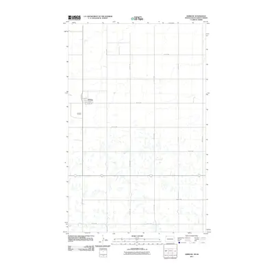
2011 Map of Ambrose
USGS Topo · Published 2011About this map
Ambrose sits at the northern edge of the North Dakota prairie, just south of the international border. This survey reflects the grid of an agricultural community where the town layout includes Valley St, Bernerd St, and numbered avenues. The landscape is dominated by a dense concentration of small prairie potholes and wetlands, illustrating the distinct glacial topography of the region. Local genealogy and history are anchored at the Ambrose Cemetery located west of the main settlement. The surrounding section lines are marked by a regular network of roads such as 106th St NW and 128th Ave NW, which facilitated the movement of grain and livestock across Divide County in the early twenty-first century.
Find a feature on this map
18 named features on this map. Tap any name to fly to it.
Don’t see what you’re looking for? This feature index may not catch every label — zoom into the map to look around manually.
Map Details
Editions of this 2011 Ambrose Map
This is the sole edition of this map. No revisions or reprints were ever made.
Other maps of this area

1948 · Crosby SW
USGS Topo · 1:24,000

1948 · Ambrose
USGS Topo · 1:24,000

1948 · Crosby
USGS Topo · 1:24,000

1948 · Crosby SE
USGS Topo · 1:24,000

1950 · Crosby
USGS Topo · 1:62,500

1953 · Williston
USGS Topo · 1:250,000

1957 · Williston
USGS Topo · 1:250,000
1983 · Colgan East
USGS Topo · 1:24,000
1983 · Colgan SE
USGS Topo · 1:24,000

1984 · Crosby
USGS Topo · 1:100,000