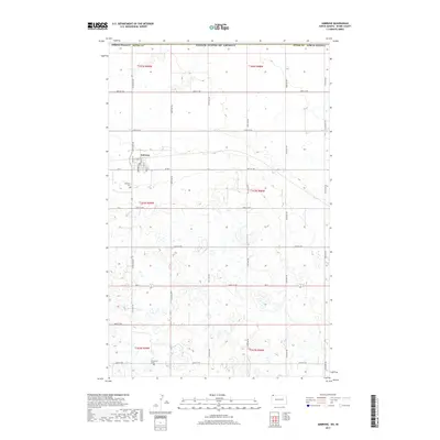
2017 Map of Ambrose
USGS Topo · Published 2017About this map
Ambrose sits at the heart of this prairie landscape, defined by a rigid grid of section lines and gravel roads that mark the agricultural development of Divide County. Located just south of the border between the United States of America and Canada, the town plan is clearly delineated by streets like Main St and Valley St. The map records the essential community infrastructure of this rural region, including the Ambrose Cem located west of the main settlement and the Immanuel Cem further south. Transportation routes such as ND 5 and Co 2 cut across the rolling terrain, which is dotted with numerous small wetlands and depressions typical of the northern plains. This topographic study captures the deliberate organization of space in a borderlands community where life centers on the section-line roads and the small town core.
Find a feature on this map
30 named features on this map. Tap any name to fly to it.
Don’t see what you’re looking for? This feature index may not catch every label — zoom into the map to look around manually.
Map Details
Editions of this 2017 Ambrose Map
This is the sole edition of this map. No revisions or reprints were ever made.
Other maps of this area

1948 · Crosby SW
USGS Topo · 1:24,000

1948 · Ambrose
USGS Topo · 1:24,000

1948 · Crosby
USGS Topo · 1:24,000

1948 · Crosby SE
USGS Topo · 1:24,000

1950 · Crosby
USGS Topo · 1:62,500

1953 · Williston
USGS Topo · 1:250,000

1957 · Williston
USGS Topo · 1:250,000
1983 · Colgan East
USGS Topo · 1:24,000
1983 · Colgan SE
USGS Topo · 1:24,000

1984 · Crosby
USGS Topo · 1:100,000