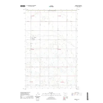
2020 Map of Ambrose
USGS Topo · Published 2020About this map
The small prairie community of Ambrose serves as the focal point for this landscape in Divide County, situated just south of the international border. This modern survey illustrates the enduring grid of the township system, with 127th Ave NW running vertically through the heart of the region. The map reveals the characteristic prairie pothole topography of the High Plains, where numerous small wetlands and depressions punctuate the terrain between the section lines. This layout provides a clear view of the rural infrastructure and land use patterns near the Canadian border, highlighting how the road network continues to define the spatial organization of these agricultural lands.
Find a feature on this map
2 named features on this map. Tap any name to fly to it.
Don’t see what you’re looking for? This feature index may not catch every label — zoom into the map to look around manually.
Map Details
Editions of this 2020 Ambrose Map
This is the sole edition of this map. No revisions or reprints were ever made.
Other maps of this area

1948 · Crosby SW
USGS Topo · 1:24,000

1948 · Ambrose
USGS Topo · 1:24,000

1948 · Crosby
USGS Topo · 1:24,000

1948 · Crosby SE
USGS Topo · 1:24,000

1950 · Crosby
USGS Topo · 1:62,500

1953 · Williston
USGS Topo · 1:250,000

1957 · Williston
USGS Topo · 1:250,000
1983 · Colgan East
USGS Topo · 1:24,000
1983 · Colgan SE
USGS Topo · 1:24,000

1984 · Crosby
USGS Topo · 1:100,000