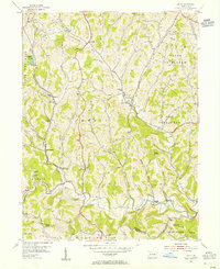
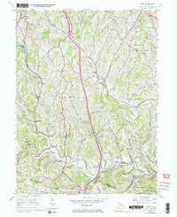
1954 Map of Amity
USGS Topo · Published 1955About this map
Ten Mile Creek and its various tributaries, including Little Ten Mile Creek and Bane Creek, carve a rolling landscape across Washington and Greene Counties. This mid-century survey illustrates a rural economy transitioning from traditional milling at sites like Harts Mill and Chambers Mill toward energy extraction, evidenced by the Lone Pine Mine, Moore Shaft, and a prominent Pipeline cutting through the terrain. The settlement of Amity serves as a central hub, surrounded by smaller communities and railroad stops like Baker Sta and Dunns Sta along the Pennsylvania Railroad. Cultural life is anchored by numerous local institutions, from the Lone Pine School to rural congregations at Bethlehem Church and Pleasant Hill Church. The northern edge is bounded by the historic National Road, emphasizing the area's long-standing importance as a transportation corridor.
Find a feature on this map
51 named features on this map. Tap any name to fly to it.
Don’t see what you’re looking for? This feature index may not catch every label — zoom into the map to look around manually.
Map Details
Editions of this 1954 Amity Map
5 editions found
Other maps of this area

1901 · Amity
USGS Topo · 1:62,500

1901 · Waynesburg
USGS Topo · 1:62,500

1904 · Amity
USGS Topo · 1:62,500

1904 · Waynesburg
USGS Topo · 1:62,500

1905 · Rogersville
USGS Topo · 1:62,500

1907 · Claysville
USGS Topo · 1:62,500

1949 · Clarksburg
USGS Topo · 1:250,000

1951 · Canton
USGS Topo · 1:250,000

1953 · Canton
USGS Topo · 1:250,000
1953 · Washington East
USGS Topo · 1:24,000
Featured Places
- Amwell Township, PA
- West Bethlehem Township, PA
- Morris Township, PA
- Baker Station, Amwell Township
- Morris Township, PA