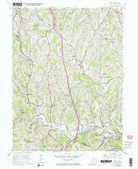
1954 Map of Amity
USGS Topo · Published 1983About this map
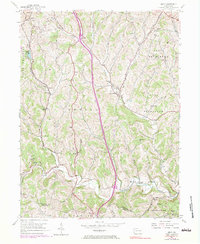
Amity and West Amity serve as the central hubs of this southwestern Pennsylvania landscape, where the deeply dissected plateau of Washington Co meets Greene Co. The map reveals a rural economy structured around the winding valleys of Tenmile Creek and Little Tenmile Creek, with numerous small family and community landmarks such as Harts Mill, Chambers Mill, and the Lone Pine Sch. Transport and industry are evident through the Penn Central rail line skirting the western hills and the presence of a Gas Pumping Sta and various mine sites. Settlements like Marianna and Lone Pine are connected by a network of ridge-top and valley roads, while social life is anchored by country institutions like the Union Sunday Sch and Bethlehem Ch. The terrain is marked by numerous small tributaries like Snipe Run and Daniels Run, illustrating the complex drainage patterns that defined local land use and property boundaries in the mid-20th century.
Find a feature on this map
43 named features on this map. Tap any name to fly to it.
Don’t see what you’re looking for? This feature index may not catch every label — zoom into the map to look around manually.
Map Details
Editions of this 1954 Amity Map
5 editions found
Other maps of this area

1901 · Amity
USGS Topo · 1:62,500

1901 · Waynesburg
USGS Topo · 1:62,500

1904 · Amity
USGS Topo · 1:62,500

1904 · Waynesburg
USGS Topo · 1:62,500

1905 · Rogersville
USGS Topo · 1:62,500

1907 · Claysville
USGS Topo · 1:62,500

1949 · Clarksburg
USGS Topo · 1:250,000

1951 · Canton
USGS Topo · 1:250,000

1953 · Canton
USGS Topo · 1:250,000
1953 · Washington East
USGS Topo · 1:24,000
Featured Places
- Amwell Township, PA
- West Bethlehem Township, PA
- Morris Township, PA
- Baker Station, Amwell Township
- Morris Township, PA