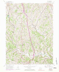
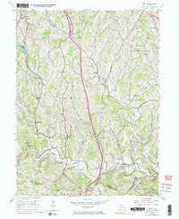
1954 Map of Amity
USGS Topo · Published 1983About this map
Tenmile Creek and its northern branch, Little Tenmile Creek, carve through the rolling uplands of Washington County, anchoring a landscape defined by small rural hubs and early industry. The map illustrates the region's mid-century transition, where established agricultural hamlets like Amity and Lone Pine coexist with the infrastructure of a changing economy. Evidence of local industry is clear near Marianna, where the Penn Central line and various mines reflect the importance of the coalfields.
Find a feature on this map
52 named features on this map. Tap any name to fly to it.
Don’t see what you’re looking for? This feature index may not catch every label — zoom into the map to look around manually.
Map Details
Editions of this 1954 Amity Map
5 editions found
Other maps of this area

1901 · Amity
USGS Topo · 1:62,500

1901 · Waynesburg
USGS Topo · 1:62,500

1904 · Amity
USGS Topo · 1:62,500

1904 · Waynesburg
USGS Topo · 1:62,500

1905 · Rogersville
USGS Topo · 1:62,500

1907 · Claysville
USGS Topo · 1:62,500

1949 · Clarksburg
USGS Topo · 1:250,000

1951 · Canton
USGS Topo · 1:250,000

1953 · Canton
USGS Topo · 1:250,000
1953 · Washington East
USGS Topo · 1:24,000
Featured Places
- Amwell Township, PA
- West Bethlehem Township, PA
- Morris Township, PA
- Baker Station, Amwell Township
- Morris Township, PA