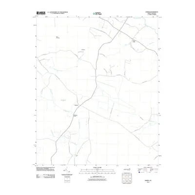
2010 Map of Ammon
USGS Topo · Published 2010About this map
Ammon and Peters Creek anchor this coastal plain landscape at the turn of the 21st century, where the winding course of Turnbull Creek and the South River define the local geography. The map reveals a transition between agricultural land and swampy basins, notably Bear Path Bay and Mill Bay, which reflect the distinctive geological depressions typical of the region. Local transit is dominated by historic routes like Old Fayetteville Rd and Cascade Canal Rd, indicating a long-standing network of inland trade. Notable river crossings such as Ammon Ford and Reeves Ford mark traditional points of passage across the creek beds. The naming of roads like Hog Haven Dr and Pork Chop Dr provides a unique cultural identifier for the modern agricultural character of the area, while family-named routes such as Culbreth Smith Rd and Lula Long Rd offer valuable leads for genealogical research.
Find a feature on this map
33 named features on this map. Tap any name to fly to it.
Don’t see what you’re looking for? This feature index may not catch every label — zoom into the map to look around manually.
Map Details
Editions of this 2010 Ammon Map
This is the sole edition of this map. No revisions or reprints were ever made.
Other maps of this area

1953 · Florence
USGS Topo · 1:250,000

1954 · Florence
USGS Topo · 1:250,000

1954 · White Lake
USGS Topo · 1:62,500

1955 · Elizabethtown
USGS Topo · 1:62,500

1959 · Roseboro
USGS Topo · 1:62,500

1959 · Garland
USGS Topo · 1:62,500

1982 · Elizabethtown
USGS Topo · 1:100,000
1986 · Garland
USGS Topo · 1:24,000
1986 · Bonnetsville
USGS Topo · 1:24,000
1986 · White Lake
USGS Topo · 1:24,000