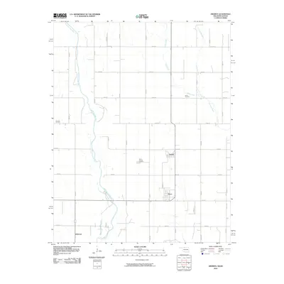
2010 Map of Amorita
USGS Topo · Published 2010About this map
Amorita and the neighboring settlement of Byron define this section of the north-central Oklahoma plains, where the grid of rural section roads meets the winding path of the Medicine Lodge River. This 2010 survey illustrates a landscape of established agriculture and scattered civic centers. Genealogy and local history researchers will find the locations of three distinct burial grounds: the Byron-Amorita Cemetery situated between its namesake towns, the Bethel Cemetery to the northeast, and the Riverside Cemetery located on the western bank of the river. The drainage of the region is further defined by Salty Creek and Little Sandy Creek, which traverse the northern and eastern portions of the quadrangle. In the south, the community of Driftwood sits along the roadway, marking a long-standing settlement point in Alfalfa County near the Kansas border.
Find a feature on this map
29 named features on this map. Tap any name to fly to it.
Don’t see what you’re looking for? This feature index may not catch every label — zoom into the map to look around manually.
Map Details
Editions of this 2010 Amorita Map
This is the sole edition of this map. No revisions or reprints were ever made.
Other maps of this area

1889 · Anthony
USGS Topo · 1:125,000

1891 · Anthony
USGS Topo · 1:125,000

1955 · Woodward
USGS Topo · 1:250,000

1955 · Pratt
USGS Topo · 1:250,000

1958 · Woodward
USGS Topo · 1:250,000

1959 · Pratt
USGS Topo · 1:250,000

1969 · Amorita
USGS Topo · 1:24,000

1969 · Burlington
USGS Topo · 1:24,000

1969 · Manchester SW
USGS Topo · 1:24,000
1969 · Manchester NW
USGS Topo · 1:24,000