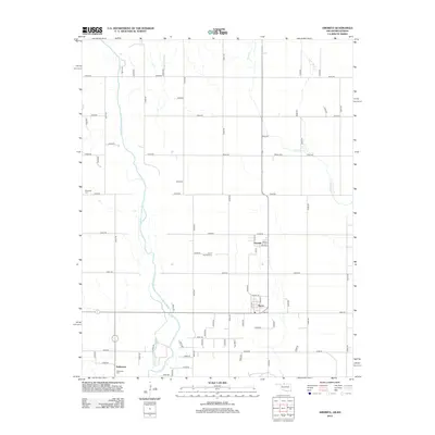
2012 Map of Amorita
USGS Topo · Published 2012About this map
The Medicine Lodge River meanders southward through Alfalfa County in this 2012 survey, defining the agricultural landscape between the small towns of Amorita and Byron. This region is characterized by its organized grid of section roads, which provides access to scattered family cemeteries and rural homesteads. Local history is anchored by sites such as the Amorita Cem, Bethel Cem, and Riverside Cem, each serving as a marker of the area's early settlement.
Find a feature on this map
63 named features on this map. Tap any name to fly to it.
Don’t see what you’re looking for? This feature index may not catch every label — zoom into the map to look around manually.
Map Details
Editions of this 2012 Amorita Map
This is the sole edition of this map. No revisions or reprints were ever made.
Other maps of this area

1889 · Anthony
USGS Topo · 1:125,000

1891 · Anthony
USGS Topo · 1:125,000

1955 · Woodward
USGS Topo · 1:250,000

1955 · Pratt
USGS Topo · 1:250,000

1958 · Woodward
USGS Topo · 1:250,000

1959 · Pratt
USGS Topo · 1:250,000

1969 · Amorita
USGS Topo · 1:24,000

1969 · Burlington
USGS Topo · 1:24,000

1969 · Manchester SW
USGS Topo · 1:24,000
1969 · Manchester NW
USGS Topo · 1:24,000