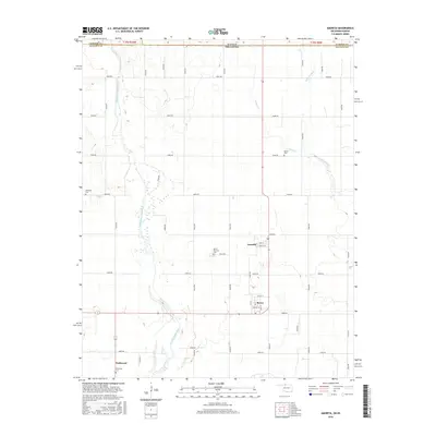
2016 Map of Amorita
USGS Topo · Published 2016About this map
Amorita and the neighboring community of Byron are the primary hubs of this agricultural area along the Kansas Oklahoma border. The landscape is defined by the winding course of the Medicine Lodge River, which cuts diagonally across the southwestern corner, and the smaller tributaries of Salty Cr and Little Sandy Cr to the northeast. Settlement patterns follow a rigid grid of rural roads, including e0060 RD and n2640 RD, connecting several local landmarks of importance to family historians. Four distinct burial grounds, including the centrally located Byron-Amorita Cem and the western Riverside Cem, suggest a history of decentralized community centers. The southern edge of the quadrangle reaches the small village of Driftwood, situated near its namesake Driftwood Cem, reflecting the early 21st-century state of these northern Alfalfa County towns.
Find a feature on this map
45 named features on this map. Tap any name to fly to it.
Don’t see what you’re looking for? This feature index may not catch every label — zoom into the map to look around manually.
Map Details
Editions of this 2016 Amorita Map
This is the sole edition of this map. No revisions or reprints were ever made.
Other maps of this area

1889 · Anthony
USGS Topo · 1:125,000

1891 · Anthony
USGS Topo · 1:125,000

1955 · Woodward
USGS Topo · 1:250,000

1955 · Pratt
USGS Topo · 1:250,000

1958 · Woodward
USGS Topo · 1:250,000

1959 · Pratt
USGS Topo · 1:250,000

1969 · Amorita
USGS Topo · 1:24,000

1969 · Burlington
USGS Topo · 1:24,000

1969 · Manchester SW
USGS Topo · 1:24,000
1969 · Manchester NW
USGS Topo · 1:24,000