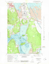
1978 Map of Anacortes South
USGS Topo · Published 1981About this map
Fidalgo Island and northern Whidbey Island are linked by the iconic Deception Pass in this late 1970s bathymetric-topographic study. The map captures the industrial and recreational character of the region, featuring the large Oil Refinery on March Point alongside natural landmarks like Mt Erie and Whistle Lake. Settlement patterns are concentrated around Anacortes in the north and small coastal communities like Similk Beach, Gibraltar, and Snee-oosh Beach further south. The Swinomish Indian Reservation occupies much of the eastern portion, bordered by the Swinomish Channel. Local history is visible in the presence of the Old Railroad Grade and the Burlington Northern line, reflecting the area's transport evolution. Cultural markers including St Marys Sch, Fern Hill Cem, and even a Drive-in Theater provide a detailed look at the social landscape of Skagit County during this era.
Find a feature on this map
64 named features on this map. Tap any name to fly to it.
Don’t see what you’re looking for? This feature index may not catch every label — zoom into the map to look around manually.
Map Details
Editions of this 1978 Anacortes South Map
3 editions found
Other maps of this area

1911 · Mount Vernon
USGS Topo · 1:125,000

1918 · Samish Lake
USGS Topo · 1:62,500

1940 · Mt Vernon
USGS Topo · 1:62,500

1943 · Mt Vernon
USGS Topo · 1:62,500

1943 · Deception Pass
USGS Topo · 1:62,500

1943 · Anacortes
USGS Topo · 1:62,500

1951 · Deception Pass
USGS Topo · 1:62,500

1951 · Anacortes
USGS Topo · 1:62,500

1954 · Bow
USGS Topo · 1:24,000

1954 · Samish Lake
USGS Topo · 1:62,500