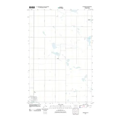
2011 Map of Anamoose
USGS Topo · Published 2011About this map
Anamoose anchors the southwestern corner of this North Dakota landscape, a prairie community defined by its rigid section lines and scattered glacial wetlands. The town's layout is meticulously detailed, showing residential streets like Avenue H W and Poplar Ave, while the nearby Saint Francis Cemetery offers a touchpoint for local genealogical research. To the north, the settlement of Aylmer sits alongside the waters of Aylmer Lake, illustrating the sparse but deliberate patterns of habitation in McHenry County during the early 21st century.
Find a feature on this map
22 named features on this map. Tap any name to fly to it.
Don’t see what you’re looking for? This feature index may not catch every label — zoom into the map to look around manually.
Map Details
Editions of this 2011 Anamoose Map
This is the sole edition of this map. No revisions or reprints were ever made.
Other maps of this area

1930 · Drake
USGS Topo · 1:62,500

1940 · Aylmer
USGS Topo · 1:62,500

1951 · Martin
USGS Topo · 1:24,000

1951 · Anamoose SW
USGS Topo · 1:24,000

1954 · Minot
USGS Topo · 1:250,000

1954 · McClusky
USGS Topo · 1:250,000

1957 · Rangeley SE
USGS Topo · 1:24,000

1958 · McClusky
USGS Topo · 1:250,000

1958 · Minot
USGS Topo · 1:250,000
1958 · Anamoose
USGS Topo · 1:24,000