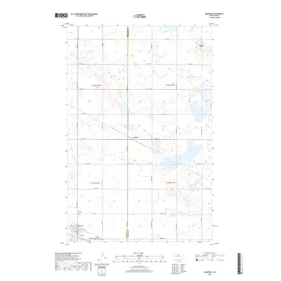
2017 Map of Anamoose
USGS Topo · Published 2017About this map
Anamoose anchors the southwestern corner of this survey, where the grid of Main St and Ave B E meets the prairie. This agricultural landscape in McHenry County is defined by its glacial potholes and internal drainage, featuring significant water bodies like Aylmer Lake and the Antelope Lakes group. The eastern portion of the map is dominated by the broad Antelope Valley, a topographic depression that cuts through the surrounding plains. For those tracing family histories in the region, the map identifies three distinct burial sites: Saint Francis Cem, Anamoose Baptist Cem, and Sunrise (EUB) Cem, each reflecting the denominational heritage of the early settlers. A rail line corridor serves the small settlement of Aylmer, which sits centrally at the junction of the county line and the sectional road grid.
Find a feature on this map
38 named features on this map. Tap any name to fly to it.
Don’t see what you’re looking for? This feature index may not catch every label — zoom into the map to look around manually.
Map Details
Editions of this 2017 Anamoose Map
This is the sole edition of this map. No revisions or reprints were ever made.
Other maps of this area

1930 · Drake
USGS Topo · 1:62,500

1940 · Aylmer
USGS Topo · 1:62,500

1951 · Martin
USGS Topo · 1:24,000

1951 · Anamoose SW
USGS Topo · 1:24,000

1954 · Minot
USGS Topo · 1:250,000

1954 · McClusky
USGS Topo · 1:250,000

1957 · Rangeley SE
USGS Topo · 1:24,000

1958 · McClusky
USGS Topo · 1:250,000

1958 · Minot
USGS Topo · 1:250,000
1958 · Anamoose
USGS Topo · 1:24,000