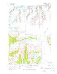
1960 Map of Anchorage A-1
USGS Topo · Published 1977About this map
Columbia Glacier dominates this mid-century Alaskan landscape, a massive ice field carving through the mountains of the Chugach National Forest. The map provides a detailed view of the ice-choked coastline where the glacier meets Columbia Bay, alongside smaller frozen flows like Meares Glacier and Pedro Glacier. This 1960 field-annotated survey reveals a dynamic glacial environment, tracing the steep elevations surrounding Columbia Peak and the high-altitude Great Nunatak. The transition from ice to water is marked by several significant inland bodies, including Kadin Lake and Terentiev Lake, which sit just above the coastal inlets of Long Bay and Heather Bay. These labels offer a precise record of the shoreline and ice extent before decades of glacial recession altered the Prince William Sound region.
Find a feature on this map
12 named features on this map. Tap any name to fly to it.
Don’t see what you’re looking for? This feature index may not catch every label — zoom into the map to look around manually.
Map Details
Editions of this 1960 Anchorage A-1 Map
3 editions found

Other maps of this area

1948 · Cordova
USGS Topo · 1:250,000

1951 · Seward
USGS Topo · 1:250,000

1951 · Anchorage
USGS Topo · 1:250,000

1951 · Cordova
USGS Topo · 1:250,000

1951 · Seward D-2
USGS Topo · 1:63,360

1951 · Seward D-1
USGS Topo · 1:63,360

1951 · Cordova D-8
USGS Topo · 1:63,360

1952 · Valdez
USGS Topo · 1:250,000

1952 · Seward D-1
USGS Topo · 1:63,360

1952 · Cordova D-8
USGS Topo · 1:63,360