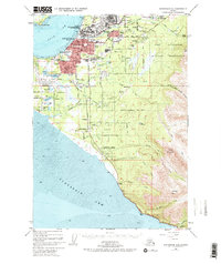
1952 Map of Anchorage A-8
USGS Topo · Published 1970About this map
Anchorage expands during the early 1950s, bounded by the waters of the Knik Arm and the extensive Fort Richardson Military Reservation. This era shows a community in rapid transition, where the street grid of the city core meets burgeoning neighborhoods like Spenard and Mountain View. The strategic importance of the region is evident in the sprawling grounds of Elmendorf Air Force Base and the dual aviation hubs of Merrill Airport and the International Airport, complemented by the Hood Seaplane Base.
Find a feature on this map
65 named features on this map. Tap any name to fly to it.
Don’t see what you’re looking for? This feature index may not catch every label — zoom into the map to look around manually.
Map Details
Editions of this 1952 Anchorage A-8 Map
4 editions found

Other maps of this area

1944 · Kenai
USGS Topo · 1:250,000

1949 · Tyonek
USGS Topo · 1:250,000

1950 · Kenai
USGS Topo · 1:250,000

1951 · Seward
USGS Topo · 1:250,000

1951 · Anchorage
USGS Topo · 1:250,000

1951 · Tyonek
USGS Topo · 1:250,000

1951 · Kenai D-1
USGS Topo · 1:63,360

1951 · Seward D-8
USGS Topo · 1:63,360

1951 · Seward D-7
USGS Topo · 1:63,360

1951 · Tyonek A-1
USGS Topo · 1:63,360