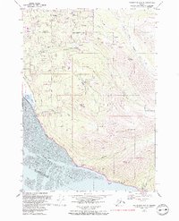
1979 Map of Anchorage A-8 SE
USGS Topo · Published 1993About this map
Turnagain Arm defines the southern edge of this landscape, where the tidal flats of the Municipality Of Anchorage meet the rising slopes of the Chugach State Park. The map documents a period of residential expansion into the hillside areas, with school sites like Huffman Sch and O'Malley Sch serving growing neighborhoods connected by O'Malley Road and Huffman Road. The infrastructure of the era is evident in the Seward Highway corridor and the presence of various Radio Towers and a Radio Facility near Blueberry Knoll.
Find a feature on this map
42 named features on this map. Tap any name to fly to it.
Don’t see what you’re looking for? This feature index may not catch every label — zoom into the map to look around manually.
Map Details
Editions of this 1979 Anchorage A-8 SE Map
2 editions found
Other maps of this area

1951 · Seward
USGS Topo · 1:250,000

1951 · Anchorage
USGS Topo · 1:250,000

1951 · Seward D-8
USGS Topo · 1:63,360

1951 · Seward D-7
USGS Topo · 1:63,360

1952 · Seward D-8
USGS Topo · 1:63,360

1952 · Seward D-7
USGS Topo · 1:63,360

1952 · Anchorage A-8
USGS Topo · 1:63,360

1953 · Anchorage A-8
USGS Topo · 1:63,360

1953 · Seward
USGS Topo · 1:250,000

1959 · Seward
USGS Topo · 1:250,000