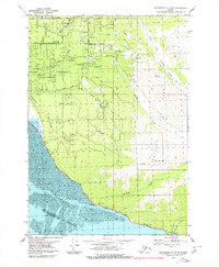
1979 Map of Anchorage A-8 SE
USGS Topo · Published 1979About this map
The coastline of Turnagain Arm meets the rising peaks of the Chugach Mountains in this detailed look at South Anchorage during the late 1970s. The landscape is defined by the corridor of the Alaska Railroad and the Seward Highway as they skirt the muddy shores toward the southeast. Small settlements like Potter and Rainbow are visible, alongside markers of local life such as the O'Malley Sch and the Landing Strip (Nystrom).
Find a feature on this map
31 named features on this map. Tap any name to fly to it.
Don’t see what you’re looking for? This feature index may not catch every label — zoom into the map to look around manually.
Map Details
Editions of this 1979 Anchorage A-8 SE Map
2 editions found
Other maps of this area

1951 · Seward
USGS Topo · 1:250,000

1951 · Anchorage
USGS Topo · 1:250,000

1951 · Seward D-8
USGS Topo · 1:63,360

1951 · Seward D-7
USGS Topo · 1:63,360

1952 · Seward D-8
USGS Topo · 1:63,360

1952 · Seward D-7
USGS Topo · 1:63,360

1952 · Anchorage A-8
USGS Topo · 1:63,360

1953 · Anchorage A-8
USGS Topo · 1:63,360

1953 · Seward
USGS Topo · 1:250,000

1959 · Seward
USGS Topo · 1:250,000