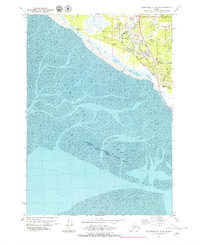
1979 Map of Anchorage A-8 SW
USGS Topo · Published 1980About this map
The mudflats of Turnagain Arm dominate the southwestern portion of this landscape, where the tides shape the shifting silt near the Municipality of Anchorage Kenai Peninsula Borough Indefinite Boundary. Along the shoreline, the transportation corridor is defined by the Alaska Railroad and the Seward Highway, which cut through a series of residential developments and community landmarks. The map documents the suburban expansion around Klatt and the various parks and institutions serving the growing population.
Find a feature on this map
25 named features on this map. Tap any name to fly to it.
Don’t see what you’re looking for? This feature index may not catch every label — zoom into the map to look around manually.
Map Details
Editions of this 1979 Anchorage A-8 SW Map
This is the sole edition of this map. No revisions or reprints were ever made.
Other maps of this area

1944 · Kenai
USGS Topo · 1:250,000

1949 · Tyonek
USGS Topo · 1:250,000

1950 · Kenai
USGS Topo · 1:250,000

1951 · Seward
USGS Topo · 1:250,000

1951 · Anchorage
USGS Topo · 1:250,000

1951 · Tyonek
USGS Topo · 1:250,000

1951 · Kenai D-1
USGS Topo · 1:63,360

1951 · Seward D-8
USGS Topo · 1:63,360

1951 · Tyonek A-1
USGS Topo · 1:63,360

1952 · Tyonek A-1
USGS Topo · 1:63,360