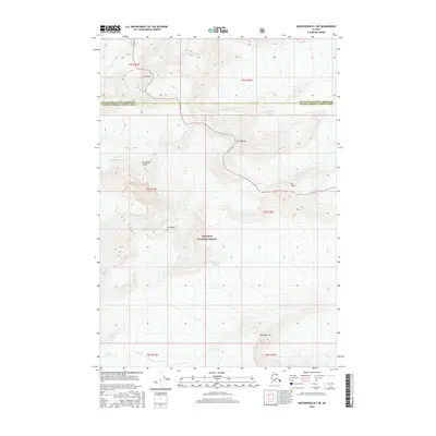
2016 Map of Anchorage B-1 NE
USGS Topo · Published 2016About this map
Ted Stevens Icefield dominates this high-altitude landscape where the boundaries of the Matanuska-Susitna Borough and Valdez-Cordova Census Area meet. The terrain is defined by massive glacial systems, including the expansive Columbia Glacier and the northern reaches of the Yale Glacier. These ice masses are punctuated by formidable peaks such as Mt Thor, Mt Valhalla, and Mt Gilbert Lewis, creating a vertical world within the Chugach National Forest. The map provides a precise record of these ice margins and summits, such as Mt Elusive and Mt Fafnir, as they appeared during the early 21st century. The density of contour lines across the Blackcliff Mtn area illustrates the extreme topography that has long challenged exploration in this part of Alaska.
Find a feature on this map
18 named features on this map. Tap any name to fly to it.
Don’t see what you’re looking for? This feature index may not catch every label — zoom into the map to look around manually.
Map Details
Editions of this 2016 Anchorage B-1 NE Map
This is the sole edition of this map. No revisions or reprints were ever made.
Other maps of this area

1951 · Anchorage
USGS Topo · 1:250,000

1952 · Valdez
USGS Topo · 1:250,000

1960 · Anchorage B-1
USGS Topo · 1:63,360

1960 · Valdez B-8
USGS Topo · 1:63,360

1960 · Valdez C-8
USGS Topo · 1:63,360

1960 · Anchorage C-1
USGS Topo · 1:63,360

1960 · Valdez
USGS Topo · 1:250,000

1962 · Anchorage
USGS Topo · 1:250,000

1979 · Anchorage
USGS Topo · 1:250,000
1993 · Valdez C-8
USGS Topo · 1:63,360