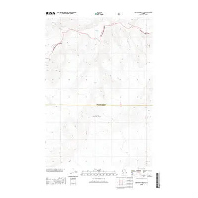
2013 Map of Anchorage B-2 NE
USGS Topo · Published 2013About this map
Matanuska-Susitna and Valdez-Cordova boundaries meet in this high-altitude landscape dominated by massive ice fields and protected wilderness. The northern section of the map is defined by the Matanuska Glacier, a significant valley glacier that flows through the southern Chugach National Forest. Further south, the Harvard Glacier sits among the peaks, illustrating the dramatic glaciology of the Chugach Mountains. This 2013 survey records the extent of these ice masses at the start of the 21st century, providing a baseline for researchers tracking the movement and recession of these prominent Alaskan landmarks. The absence of roads or settlements emphasizes the remote, undeveloped nature of this protected forest land, where the topography is shaped entirely by natural forces.
Find a feature on this map
4 named features on this map. Tap any name to fly to it.
Don’t see what you’re looking for? This feature index may not catch every label — zoom into the map to look around manually.
Map Details
Editions of this 2013 Anchorage B-2 NE Map
This is the sole edition of this map. No revisions or reprints were ever made.
Other maps of this area

1951 · Anchorage
USGS Topo · 1:250,000

1960 · Anchorage C-2
USGS Topo · 1:63,360

1960 · Anchorage B-1
USGS Topo · 1:63,360

1960 · Anchorage B-2
USGS Topo · 1:63,360

1960 · Anchorage C-1
USGS Topo · 1:63,360

1962 · Anchorage
USGS Topo · 1:250,000

1979 · Anchorage
USGS Topo · 1:250,000
1993 · Anchorage C-2
USGS Topo · 1:63,360
2013 · Anchorage C-2 SW
USGS Topo · 1:25,000

2013 · Anchorage B-2 SW
USGS Topo · 1:25,000