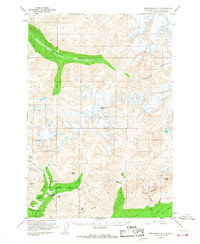
1950 Map of Anchorage D-6
USGS Topo · Published 1968About this map
Mining operations and high mountain peaks define this territory within the Talkeetna Mountains during the mid-twentieth century. Hard rock extraction is concentrated in the southwest, where the Snowbird Mine, Mabel Mine, and Rae-Wallace Mine sit along the drainages of Archangel Creek and Reed Creek. This industrial footprint is connected by a singular Road leading toward the Little Susitna Roadhouse, a critical stop for travelers and miners navigating the high-altitude terrain.
Find a feature on this map
37 named features on this map. Tap any name to fly to it.
Don’t see what you’re looking for? This feature index may not catch every label — zoom into the map to look around manually.
Map Details
Editions of this 1950 Anchorage D-6 Map
5 editions found
Other maps of this area

1949 · Anchorage D-5
USGS Topo · 1:63,360

1949 · Anchorage D-7
USGS Topo · 1:63,360

1949 · Talkeetna Mountains A-4
USGS Topo · 1:63,360

1950 · Talkeetna Mountains
USGS Topo · 1:250,000

1950 · Anchorage D-6
USGS Topo · 1:63,360

1950 · Anchorage C-7
USGS Topo · 1:63,360

1950 · Talkeetna Mountains A-5
USGS Topo · 1:63,360

1951 · Anchorage
USGS Topo · 1:250,000

1951 · Anchorage C-6
USGS Topo · 1:63,360

1951 · Anchorage C-7
USGS Topo · 1:63,360