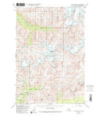
1950 Map of Anchorage D-6
USGS Topo · Published 1984About this map
Mining operations and prospect sites dominate the southern reaches of this landscape in the mid-century, concentrated around the valleys of the Little Susitna River and Archangel Creek. The Snowbird Mine, Mabel Mine, and Fern Mine highlight an era of active extraction tucked beneath the peaks of Arkose Ridge. Near the river, the Little Susitna Roadhouse stands as a vital stop for travelers navigating the route between Willow and Palmer. To the north, the terrain transitions into a more glaciated wilderness, defined by the sweeping Kashwitna River and the high ice of Mint Glacier. The presence of numerous named prospects like the Webfoot Prospect and Archangel Prospect suggests a period of intense geological investigation into the mineral-rich slopes surrounding Idaho Peak and Montana Peak.
Find a feature on this map
31 named features on this map. Tap any name to fly to it.
Don’t see what you’re looking for? This feature index may not catch every label — zoom into the map to look around manually.
Map Details
Editions of this 1950 Anchorage D-6 Map
5 editions found
Other maps of this area

1949 · Anchorage D-5
USGS Topo · 1:63,360

1949 · Anchorage D-7
USGS Topo · 1:63,360

1949 · Talkeetna Mountains A-4
USGS Topo · 1:63,360

1950 · Talkeetna Mountains
USGS Topo · 1:250,000

1950 · Anchorage D-6
USGS Topo · 1:63,360

1950 · Anchorage C-7
USGS Topo · 1:63,360

1950 · Talkeetna Mountains A-5
USGS Topo · 1:63,360

1951 · Anchorage
USGS Topo · 1:250,000

1951 · Anchorage C-6
USGS Topo · 1:63,360

1951 · Anchorage C-7
USGS Topo · 1:63,360