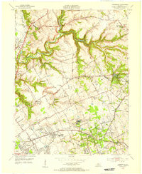
1955 Map of Anchorage
USGS Topo · Published 1956About this map
Anchorage and its neighboring residential communities define the landscape of eastern Jefferson County in the mid-1950s. The area is characterized by large institutional campuses and scattered rural settlements, ranging from the Kentucky Military Institute to the sprawling grounds of Central State Hospital at Lakeland. To the south, the established neighborhoods of Lyndon and Ormsby Village sit near the headwaters of the Middle Fork Beargrass Creek. Local transit and social life are anchored by landmarks like the Louisville and Nashville railroad line and a network of winding roads such as Covered Bridge Road and Brownsboro Road. Notable concentrations of small communities like Griffytown and Berrytown appear alongside older institutions including the Kentucky Childrens Home and St Thomas Seminary, reflecting the complex social geography of the era before extensive suburban subdivision reached this far north of the city.
Find a feature on this map
74 named features on this map. Tap any name to fly to it.
Don’t see what you’re looking for? This feature index may not catch every label — zoom into the map to look around manually.
Map Details
Editions of this 1955 Anchorage Map
This is the sole edition of this map. No revisions or reprints were ever made.
Other maps of this area

1905 · Prospect
USGS Topo · 1:62,500

1907 · Louisville
USGS Topo · 1:62,500

1912 · Prospect
USGS Topo · 1:62,500

1929 · Taylorsville
USGS Topo · 1:62,500

1932 · La Grange
USGS Topo · 1:62,500

1937 · Jeffersonville
USGS Topo · 1:24,000

1937 · Charlestown
USGS Topo · 1:24,000

1938 · Owen
USGS Topo · 1:24,000

1946 · Jeffersonville
USGS Topo · 1:24,000

1948 · Owen
USGS Topo · 1:24,000