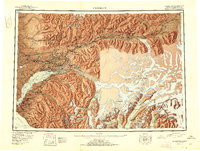
1951 Map of Anchorage
USGS Topo · Published 1951About this map
Anchorage and its surrounding glacial landscape are captured here in the early 1950s, a period of significant military and infrastructure development for the region. The map highlights the strategic importance of Fort Richardson and Elmendorf Field north of the city, while the Alaska Railroad line snakes along the Knik Arm to connect the growing settlements of Wasilla and Palmer. To the north, the Matanuska Valley shows a dense concentration of mining activity, including the Independence Mine and Gold Bullion Mine in the Talkeetna Mountains, reflecting the area’s industrial roots.
Find a feature on this map
98 named features on this map. Tap any name to fly to it.
Don’t see what you’re looking for? This feature index may not catch every label — zoom into the map to look around manually.
Map Details
Editions of this 1951 Anchorage Map
4 editions found

Other maps of this area

1944 · Kenai
USGS Topo · 1:250,000

1948 · Cordova
USGS Topo · 1:250,000

1948 · Anchorage D-3
USGS Topo · 1:63,360

1948 · Anchorage D-2
USGS Topo · 1:63,360

1948 · Anchorage D-4
USGS Topo · 1:63,360

1948 · Anchorage D-1
USGS Topo · 1:63,360

1949 · Tyonek
USGS Topo · 1:250,000

1949 · Anchorage D-5
USGS Topo · 1:63,360

1949 · Anchorage D-7
USGS Topo · 1:63,360

1949 · Talkeetna Mountains A-1
USGS Topo · 1:63,360