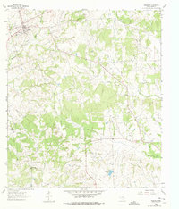
1961 Map of Anderson
USGS Topo · Published 1975About this map
Anderson serves as the focal point of this Grimes County landscape, situated near the headwaters of Holland Creek and Nebletts Creek. The 1961 field survey reveals a community organized around its civic and religious foundations, notably the Fairground and the prominent St Stanislaus Ch. Moving south across the open spaces of Grimes Prairie, the map documents a rural network of small schoolhouses and churches that anchored local life in the mid-twentieth century, including the Grimes Prairie Sch and Pleasant Grove Ch.
Find a feature on this map
31 named features on this map. Tap any name to fly to it.
Don’t see what you’re looking for? This feature index may not catch every label — zoom into the map to look around manually.
Map Details
Editions of this 1961 Anderson Map
2 editions found
Other maps of this area

1914 · Navasota
USGS Topo · 1:62,500

1954 · Beaumont
USGS Topo · 1:250,000

1954 · Austin
USGS Topo · 1:250,000

1956 · Carlos
USGS Topo · 1:62,500

1957 · Beaumont
USGS Topo · 1:250,000

1958 · Navasota
USGS Topo · 1:24,000

1958 · Courtney
USGS Topo · 1:24,000

1960 · Carlos
USGS Topo · 1:24,000

1961 · Anderson
USGS Topo · 1:24,000

1961 · Stoneham
USGS Topo · 1:24,000