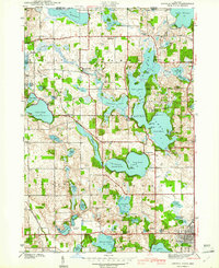
1941 Map of Angola West
USGS Topo · Published 1941About this map
Pokagon State Park and the complex glacial kettle lake systems of Steuben County dominate this 1939 survey. The map details the interconnected basins of James Lake, including the Upper, Middle, and Lower Basin, alongside the distinct basins of Crooked Lake. At the park's heart sits the Potawatomi Inn, while the presence of a CCC Camp reflects the labor that helped shape the park's early infrastructure. The landscape is a patchwork of water and small settlements like Nevada Mills, Inverness, and Jamestown. Cultural landmarks of the era include the County Farm and Tri State Airport, illustrating the rural social and logistical services of the time. Local history is anchored by several rural cemeteries and the Silver Lake Chapel, providing a clear view of the area's pioneer and early twentieth-century community hubs before the post-war expansion of lakeside recreation.
Find a feature on this map
75 named features on this map. Tap any name to fly to it.
Don’t see what you’re looking for? This feature index may not catch every label — zoom into the map to look around manually.
Map Details
Editions of this 1941 Angola West Map
2 editions found
Other maps of this area

1939 · Hamilton
USGS Topo · 1:24,000

1939 · Angola East
USGS Topo · 1:24,000

1940 · Orland
USGS Topo · 1:24,000

1941 · Orland
USGS Topo · 1:24,000

1941 · Angola West
USGS Topo · 1:24,000

1942 · Ashley
USGS Topo · 1:24,000

1942 · Angola West
USGS Topo · 1:24,000

1942 · Stroh
USGS Topo · 1:24,000

1947 · Angola East
USGS Topo · 1:24,000

1948 · Hamilton
USGS Topo · 1:24,000