
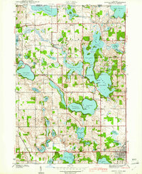
1941 Map of Angola West
USGS Topo · Published 1941About this map
The glacial lakes of Steuben County dominate this landscape, which centers on the extensive Lake James complex and the established Pokagon State Park. In the years before the second World War, the area had already become a significant recreational hub, featuring the Potawatomi Inn, a Boys Camp, and a CCC Camp. This survey captures the rural infrastructure supporting these lakeside communities, including the County Farm and a network of schools and churches like the Collins Sch and Silver Lake Chapel. To the south, the city of Angola begins to expand toward the Tri State Airport. The map meticulously details the small, often family-named water bodies such as Sally Owen Lake and Rhodes Lake, alongside older crossroad settlements like Nevada Mills and Inverness.
Find a feature on this map
76 named features on this map. Tap any name to fly to it.
Don’t see what you’re looking for? This feature index may not catch every label — zoom into the map to look around manually.
Map Details
Editions of this 1941 Angola West Map
2 editions found
Other maps of this area

1939 · Hamilton
USGS Topo · 1:24,000

1939 · Angola East
USGS Topo · 1:24,000

1940 · Orland
USGS Topo · 1:24,000

1941 · Orland
USGS Topo · 1:24,000

1942 · Ashley
USGS Topo · 1:24,000

1942 · Angola West
USGS Topo · 1:24,000

1942 · Stroh
USGS Topo · 1:24,000

1947 · Angola East
USGS Topo · 1:24,000

1948 · Hamilton
USGS Topo · 1:24,000

1953 · Fort Wayne
USGS Topo · 1:250,000