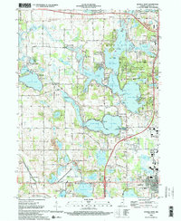
1992 Map of Angola West
USGS Topo · Published 1993About this map
Pokagon State Park and the sprawling glacial lake systems of Steuben County dominate this 1990s landscape, illustrating a region defined by its complex hydrology and recreational development. The map details the interconnected basins of Lake James, Snow Lake, and Jimmerson Lake, providing a clear view of the shorelines and islands like Deer Island and Eagle Island before later modern expansions. The presence of Nevada Mills and the Old Grade Railroad suggests the earlier industrial and transport foundations of the area, while the growth of Angola is anchored by the campus of Tri-State University. For genealogists and local historians, the sheet preserves the locations of rural landmarks such as the Lake Gage Cem and Jamestown Cem, alongside the Steuben County Rest Home and the small settlements of Inverness and Panama.
Find a feature on this map
78 named features on this map. Tap any name to fly to it.
Don’t see what you’re looking for? This feature index may not catch every label — zoom into the map to look around manually.
Map Details
Editions of this 1992 Angola West Map
2 editions found
Other maps of this area

1939 · Hamilton
USGS Topo · 1:24,000

1939 · Angola East
USGS Topo · 1:24,000

1940 · Orland
USGS Topo · 1:24,000

1941 · Orland
USGS Topo · 1:24,000

1941 · Angola West
USGS Topo · 1:24,000

1942 · Ashley
USGS Topo · 1:24,000

1942 · Angola West
USGS Topo · 1:24,000

1942 · Stroh
USGS Topo · 1:24,000

1947 · Angola East
USGS Topo · 1:24,000

1948 · Hamilton
USGS Topo · 1:24,000